Dec 16: Final Call for Wintry Event Tonight-Saturday AM

Here’s our final call on wintry precipitation tonight into tomorrow morning…

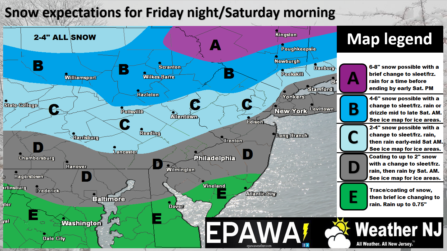
Click here to view the full resolution snow impact map.

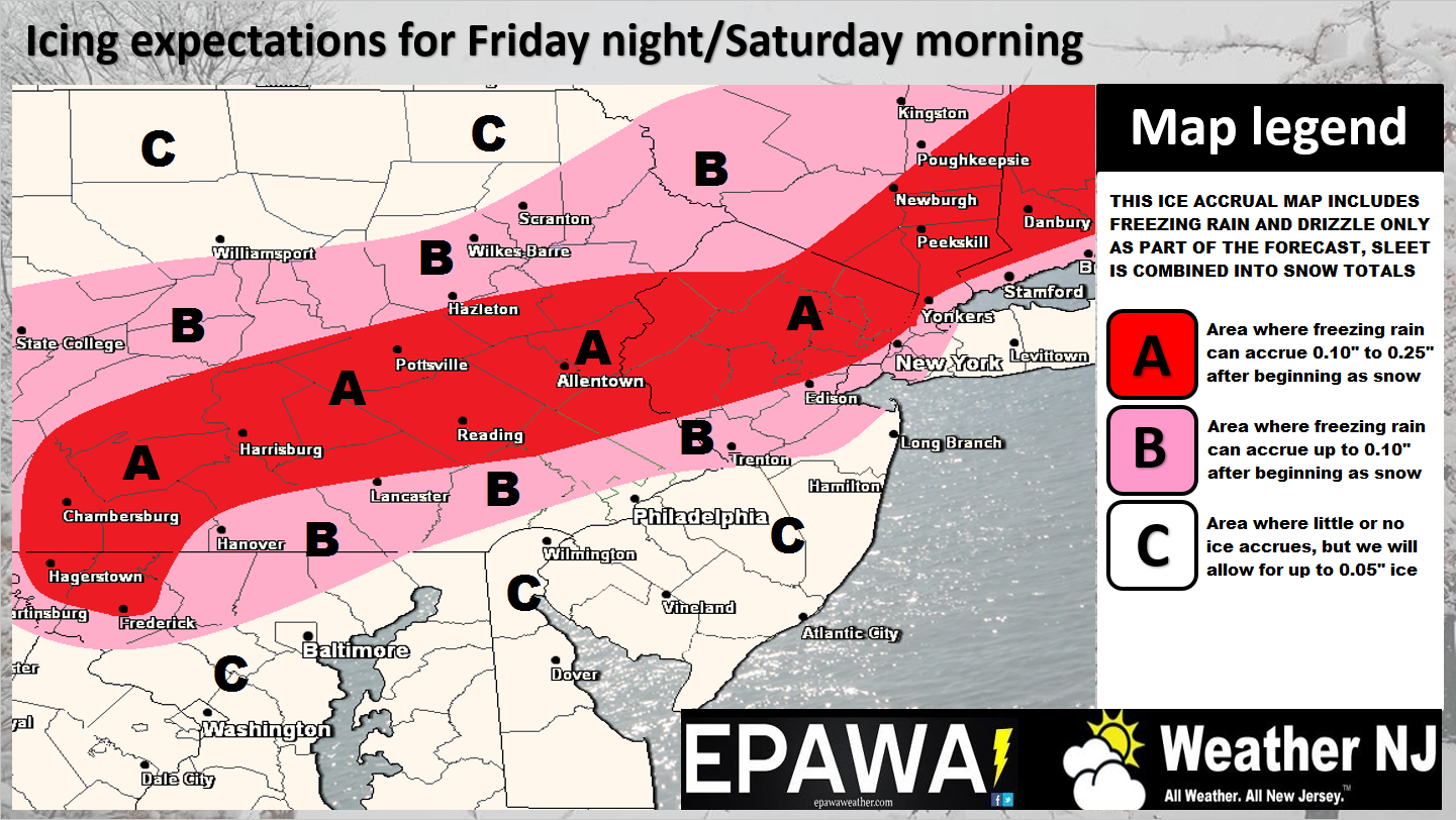
Click here to view the full resolution ice impact map.
Disco: Just to review… We have a departing high and approaching low placing us in the center of their combined warmer southerly flow. This warmer flow will drive temperatures above freezing from S to N. The change will first happen aloft before the surface catches up. We also have precipitation approaching from the W. Precipitation will move through and fall before temperatures rise above freezing and that creates our wintry concern overnight and into tomorrow morning. There is no doubt that temperatures will eventually rise above freezing, even for NNJ. With that said, temperatures will rise above freezing first in SNJ then CNJ and again, ultimately NNJ. For this reason, wintry impacts are greater in the northern half of the state than the southern half.
As far as the first part of this system, which could happen as early as 10PM for parts of WNJ, only a light-to-moderate snow event is expected before the changeover begins. As the map suggests, we’re not advocating crazy totals. Snow should end from 5AM to 11AM from SNJ to NNJ.
The second part of this system is of higher concern to us. That being the possible icy transition. It doesn’t take much ice to cause travel concerns. Higher accrual amounts however can additionally cause problems with power lines, tree branches, etc. SNJ/SENJ has the least amount of expected ice. That’s not to say no ice expected, but definitely the least amount and shortest period of possibility. Parts of CNJ and most of NNJ should expect significant icing as the ice impact map above suggests. This can be in the form of sleet and/or freezing rain.
The next part of this system is pretty simple. Everyone should eventually see rain by late Saturday morning/early Saturday afternoon before an expected lull in precipitation Saturday night. Rain could then pick up again for Sunday, on-and-off, before possibly ending as snow again Sunday evening. Let’s see how we’re doing Saturday night before making that call. It would only be a few more inches, if anything at all.
Wildcards: Some model guidance has been suggesting the presence of a meso-low off the coast of New Jersey tomorrow morning. If this happens, it could delay the warming and buy the transition an hour or two. Therefore the surface could end up with higher snow totals and/or more ice. There is also a wildcard in the other direction which would be lower QPF (moisture) in the precipitation shield. This could create virga (snow that evaporates before falling but shows on radar). Eventually snow would reach the ground once the atmosphere saturates but at the cost of evaporated totals. So those are the differentials we can think of for argument sake as to what could go wrong in either direction. Our maps above however represent our best evidenced-based prediction after examining model guidance and making live observations in the Western-Central US.
In English: Snow should break out overnight before changing to ice and then rain by late morning. The change will occur from SNJ to NNJ and therefore NNJ will be subject to more snow and/or ice than southern parts of the state. It could really be messy on the roads between midnight and late morning, especially for parts of CNJ and all of NNJ. Rain should then be on-and-off from Saturday afternoon through Sunday before possibly changing back to wintry precipitation Sunday night. Please be safe! JC
Jonathan Carr (JC) is the founder and sole operator of Weather NJ, New Jersey’s largest independent weather reporting agency. Since 2010, Jonathan has provided weather safety discussion and forecasting services for New Jersey and surrounding areas through the web and social media. Originally branded as Severe NJ Weather (before 2014), Weather NJ is proud to bring you accurate and responsible forecast discussion ahead of high-stakes weather scenarios that impact this great garden state of ours. All Weather. All New Jersey.™ Be safe! JC


