Model guidance continues to suggest an east coast winter snow storm this weekend. A few other models have hopped on the train as well. Timing now looks like Saturday into Sunday which could cause holiday shopping headaches and possibly a White Christmas. Let’s get nerdy:
The energy responsible for this storm is still over the Pacific Ocean. It will not enter the western CONUS (CONtinental US) until ~Wednesday. With that being said, model guidance will obtain a much better handle on the system once the energy is over land sensors Wednesday/Wednesday night. Here’s the energy approaching the west coast on the GOES West satellite water vapor:
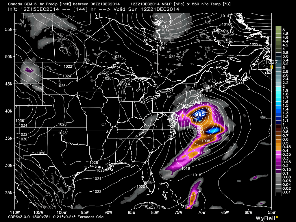
Today the upgraded GFS, Canadian, UKMET, and NAVGEM woke up to what the European has been screaming for 5 runs now—an east coast winter snow storm for many in the mid-Atlantic US. From the top down, the primary synoptic drivers of this system come from the split flow jet stream and 50/50 low that will setup over E. Canada. Energy will split off the Pacific and re-unite over the central-eastern US in a phase. This phased system will either track northerly over Virginia-Delmarva or southerly over North Carolina. The former scenario would result in a major snow storm for along I-95 and up through NWNJ (rain to snow accumulations for coast). The latter would result in a major snow storm for SNJ (DC through Baltimore and Atlantic City/Cape May).
So that’s where we’re at right now. Whether or not the system takes the northerly or southerly track will depend on the 50/50 low that sets up over E. Canada. If that low stays in place longer, then it will push the storm track to the southerly route. If it drifts east faster, then the storm track will verify along the northerly route as it will be allowed to turn up the coast a bit before moving out. Storm vs. no storm is no longer an issue for the east coast. I’m now just determining the final track and intensity within the previously mentioned E. CONUS-Atlantic Ocean ejection (VA/Delmarva or NC).
Until this track is locked-onto Wednesday-Wednesday night (when model guidance contains land-sampled data) the track will be uncertain. With that being said, expect models to swing north and south until then. I’ll put my first snow map out on Wednesday evening which will be more probability-based than accumulation amount based. Until the track and intensity narrows down, snow/rain lines are pointless.
The operational European model was south with the system today while it’s ensemble members were north. The old GFS was south while it’s upgraded parallel version was north. The model that split the uprights was the Canadian pictured below. This is the 12Z Canadian showing 850mb pressure and precipitation between 1AM and 7AM Sunday morning, December 21.
In English: A winter snow storm is coming to the east coast this Saturday-Sunday. Timing could still drift a bit earlier or later but that’s what it looks like right now. Once I get a better handle on storm track and intensity, I will be able to make a map for you outlining where I think it will snow the hardest on the east coast. That should come Wednesday evening. Expected accumulation amounts will not be possible until probably Thursday. For now we patiently take each model with the grain of salt with the overall idea that the storm is going to happen. Be safe! JC
Model images reproduced with permission from Dr. Ryan Maue of WeatherBell Analytics.
Jonathan Carr (JC) is the founder and sole operator of Weather NJ, New Jersey’s largest independent weather reporting agency. Since 2010, Jonathan has provided weather safety discussion and forecasting services for New Jersey and surrounding areas through the web and social media. Originally branded as Severe NJ Weather (before 2014), Weather NJ is proud to bring you accurate and responsible forecast discussion ahead of high-stakes weather scenarios that impact this great garden state of ours. All Weather. All New Jersey.™ Be safe! JC
