Dec 14: Snow Map for Saturday Morning

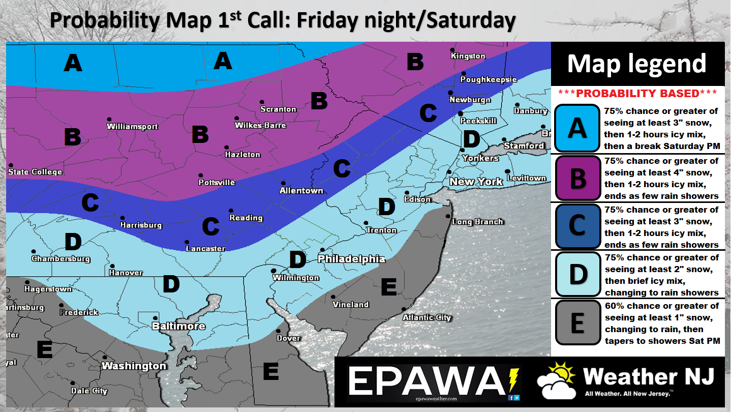
A thump of wintry-precipitation is likely this Saturday morning. Here’s our initial call…

Click here to view impact map in full resolution.
The theme of this event will be super cold air tonight through Friday night -> to a wintry thump of snow and ice Saturday morning -> to all rain by late-Saturday morning statewide. Extreme NNJ, especially elevations, should stay below freezing at the surface the longest and therefore should changeover last. Said changeover from snow to ice to rain will occur from extreme SNJ to extreme NNJ between early Saturday AM hours and daybreak. As soon as southerly flow pushes in warmer 850mb temperatures, the changeover in precipitation type will begin aloft. The surface and lower-level of the atmosphere will hold onto cold longer than the lower-mid levels aloft. For this reason we should see a period of icing, more probable in NNJ/CNJ than SNJ. So again…snow to ice to rain…quicker change for SNJ…more ice for CNJ/NNJ…slower change for NNJ but everyone eventually should go to rain by noon or so.
We’ll then likely see a lull in precipitation on Saturday from noon to midnight before rain picks back up again for most of Sunday. On Sunday (afternoon-evening), there is a small chance that rain could change back to wintry-type precipitation along the cold front moving in but the jury is still out on that. We should have a better idea on that by the time we issue our final call tomorrow or Friday.
My Pocket Meteorologist alerts went out to those subscribed earlier today and will be sent hyper-locally as required heading into this event. MPM forum members are receiving guaranteed round-the-clock model analysis and interaction (questions guaranteed answered by forum forecasters). You can sign up for either winter service here. Otherwise, nightly public articles with impact maps such as these will continue before now-casting begins late Friday night.
In English: It’s going to be cold as heck tonight through Friday night. We should see a wintry thump (snow and ice) early Saturday morning (after midnight and before 7AM for most – see map above). All precipitation should change to rain (SNJ first then CNJ and lastly NNJ). We’ll then see a break in rain from Saturday afternoon/early evening until midnight/just after. Sunday then looks mostly rainy but possibly ending as snow and ice later Sunday afternoon/evening. Saturday and Sunday should be fine to drive around as temperatures surge quite mildly with the rain. The biggest threats for travel exist early Saturday morning (see map above) and later Sunday night if rain changes back over to snow. Please be safe! JC
Jonathan Carr (JC) is the founder and sole operator of Weather NJ, New Jersey’s largest independent weather reporting agency. Since 2010, Jonathan has provided weather safety discussion and forecasting services for New Jersey and surrounding areas through the web and social media. Originally branded as Severe NJ Weather (before 2014), Weather NJ is proud to bring you accurate and responsible forecast discussion ahead of high-stakes weather scenarios that impact this great garden state of ours. All Weather. All New Jersey.™ Be safe! JC


