

Cold and Windy as Snowstorm Grazes SENJ
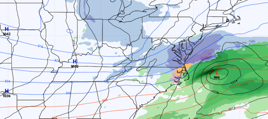
Discussion: Heartbreak for the snow lover has continued overnight as models trended even further SE than they did yesterday. Energy is now sampled over land for both pieces of energy involved, and it still looks like the southern stream is too fast for the northern stream. That means the phase will not happen quick enough to halt the SE US surface low and hug it closer to the coast. Additionally, the Arctic suppression out of the N is too strong (your feeling it now) which is forcing more of a south track of the low as it crosses the SE US. Because of the unfavorable suppression and timing, the Wednesday-Thursday snowstorm is now expected to miss NJ to the S aside from a possible SENJ graze of flurries or lightly accumulating snow showers. And even that is very uncertain at this point. This is the product of a weak El Nino ENSO phase coupled with a negative phase of the Eastern Pacific Oscillation. The -EPO stopped the raging Pacific jet from warming the US. The negative phase of the AO allowed Arctic air to spill down into the central and eastern US. But the weak blocking prevented any snowstorm from tracking favorably up the east coast and instead allowed all lows to slip away to the E with a suppressed zonal track within mostly positive-tilted troughs. Some might call this atmospheric memory when a pattern sustains for multiple storms in a row. It is what it is.
As a snow lover, I am just as disappointed as many of you. I am glad, however, that this was identified while still in the “signal tracking” phase rather than after we issued an official snow map (within 48 hours of the event). That would be much more of a nightmare. As I stated at the start of tracking, phases are risky business and deliver heartbreak up to the 11th hour (remember Jan 2015?). There’s a reason we were waiting until tomorrow to issue an official snow map and forecast. Now with all of this said, could it come back to the NW? Sure it could, as we still have 54 hours to peak reach of snow bands from the storm out to sea. But I would keep low expectations for anything more than a SENJ graze of flurries-to-snow showers at most. And with that, low temperatures will allow for very high snow ratios. So, if only a tenth of an inch of liquid were to fall out of the sky over Cape May County/Atlantic City area, it would amount to a 1.5 to 2 inch snow accumulation rather than just a one inch snow accumulation. So, if anything can get going down there, it could produce surprising light accums if you are now expecting nothing. I’ll be watching but again, expectations are very low for this coming back NW beyond the extreme SENJ coast.
As far as this week goes, it’s no secret that cold air has moved back into the region. The weekend system had its associated trough and that will now become a 50/50 low as another trough moves in with the New Jersey Virginia/Delaware snowstorm. Cross-polar flow aloft over packed lower-level isobars suggests that this week will be windy, not just cold. Not as windy as last night (Sunday night) but persistently breezy-to-gusty at times and mostly out of the NW or W/NW right through Friday. Once we get to the weekend, the trough moves out and some ridging develops over NJ, producing highs in the 40s, even 50s by midweek.
So where are we in the baseball game analogy? Well, we had the bases loaded with our cleanup hitter at bat for this Wednesday-Thursday. Had the signal produced the statewide KABOOM, I probably would have walked out of the stadium myself with a chin-up game win. This batter has instead stuck out. NNJ and CNJ are below average snowfall for this time of season while SNJ/SENJ is above…more evidence of the atmospheric memory (suppression) this weekend. I’d love to tell you that spring weather will set up next week and last into summer. But we all know I cannot do that. I’d say we have one out in the 8th inning…5 outs left…5 weeks. Brings us to late-March where you need a freak situation for snow to happen after that. I’ll never toss winter in mid-February though, not after Marches like 2014 and 2018.
I understand emotions are high with this week’s loss. There will be a lot of: “why even talk about storms until 2 days before?” “I’ll believe it when I see it.” “what a total bust” Etc. Not sure how something can bust when an official forecast was never made. The actual reality is that we were tracking a strong signal that fell off before forecast time…but whatever. Again, I get it. I am right there with you. I anticipate a lot of disappointment that it didn’t work out but I will not allow tolerate attacks or lashing out with hate or profanity…that’s an instaban.
If the storm were to miraculously trend back NW, I’ll be reporting accordingly. But otherwise, expect updates to be light and not in storm mode for the trace/light snow still possible from the fringe of this storm Wednesday night into Thursday.
Forecast
Monday (Feb 17) high temperatures should range from 30-40 NNJ to SNJ. Skies should remain mixed with more sun than flat-bottom wind clouds. Winds should remain gusty out of the W/NW. Overnight lows should range from about 10 to mid-20s NNJ to SNJ.
Tuesday (Feb 18) high temperatures should range from 25-32 NNJ to SNJ. Skies should be mostly clear. Winds should remain out of the W/NW but relax from gusty to breezy. Overnight lows should range from single digits in NNJ to near-20 in SNJ (teens for much of NJ).
Wednesday (Feb 19) high temperatures should range from mid-20s to near-30 NNJ to SNJ. Skies should be mixed with sun and clouds for the northern 2/3 of NJ. SNJ, especially extreme SENJ, has a small chance of flurries and snow showers with trace/light accumulation possible. No major storm though and even lighter fringe snowfall from the snowstorm is uncertain. Such would favor PM hours over AM hours. Winds should be light-to-breezy out of the W/NW. Overnight lows should range from near-10 to near-25 NNJ to SNJ as light snow chances persist for SENJ overnight into Thursday.
Thursday (Feb 20) high temperatures shouldrange from 25-30 NNJ to SNJ. Skies should range from clear in NNJ to mixed sun and clouds for CNJ to mostly cloudy in SNJ with flurries/snow showers possible for the first half of the day in SENJ. Trace/light snow accumulations are possible. The further SE in SENJ you go, the better the chance. Very light and powdery snow but a very sharp cut-off of no snow somewhere through SNJ. Winds should be light-to-breezy out of the NW. Overnight lows should fall to the 15-20 range for most NJ locations.
Friday (Feb 21) high temperatures shouldpush up to the 35-40 range for most NJ locations. Skies should be mixed with more sun than clouds. Winds should be breezy, possibly gusty at times (to 40mph), out of the NW. Overnight lows should fall back to the 15-20 range for most NJ locations.
An early look at the weekend (Feb 22-23) indicates continued moderation with high temps reaching into the 40s by the end of the weekend. It looks clear and dry though. The moderation should extend next week with 50s on the table by midweek for CNJ/SNJ. Like I said above in the discussion, I will keep Wed-Thurs on the backburner should it trend back to the NW to more than just flurries and snow showers for extreme SENJ only. But I advise you to keep expectations low for such. Have a great rest of your Monday and please be safe! JC
Premium Services
KABOOM Club offers ad-free content, inside info forecast discussion, your questions answered, and early storm impact maps and video releases (ahead of the public). At $1.99 per month, it’s an extremely feasible way to show additional support for Weather NJ and you can can turn it on and off for however many months you wish. Think of it as a tip jar with perks. The public eventually sees all info discussed in premium areas. Available onFacebook or Patreon.
My Pocket Meteorologist (MPM), in partnership with EPAWA Weather Consulting, offers professional/commercial interests, whose businesses depend on outdoor weather conditions (snow plowing, landscaping, construction, etc.), with hyper-local text message alerts/forecasts and access to the MPM premium forum—the most comprehensive and technical forecast discussion available for PA and NJ.
Jonathan Carr (JC) is the founder and sole operator of Weather NJ, New Jersey’s largest independent weather reporting agency. Since 2010, Jonathan has provided weather safety discussion and forecasting services for New Jersey and surrounding areas through the web and social media. Originally branded as Severe NJ Weather (before 2014), Weather NJ is proud to bring you accurate and responsible forecast discussion ahead of high-stakes weather scenarios that impact this great garden state of ours. All Weather. All New Jersey.™ Be safe! JC


LOCAL FORECAST | INTERACTIVE RADAR | LATEST NJ WEATHER ALERTS | WEDDING FORECAST| PRIVACY POLICY
© Copyright 2025 Weather NJ LLC. All Rights Reserved.
Some information that can be found on our website is provided by a private weather station and is not an officially recognized station for weather reporting. Though we always strive to achieve accurate reporting for our own use, it is important that you do NOT depend on the data provided here for any purpose.
