Lots of rain on the way. Let’s break it down…
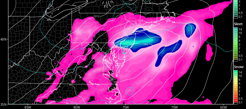
Discussion: The jet stream is about to take a dip over the E US. An upper-level shortwave is just getting started N of Montana which will descend and develop into a closed-off low over the PA/NJ/MD/DE region. It will then pull away out into the ocean as it fizzles and absorbs back into the jet stream. At 850mb this means a warm spike in temperature and humidity ahead of the low followed by a pull-down of cooler and drier air behind the low (routine cyclonic synoptics). At the surface this means an organized center of circulation (~999-1002mb) that moves across the Delmarva Peninsula before passing out to sea just to the S of the 40N/-70W benchmark…a summer coastal storm. This should bring a solid period of moderate-to-heavy rainfall to New Jersey between Friday afternoon and Saturday late-morning. Light-to-moderate rain could linger through Saturday into Sunday but the jury is still out on such. Here are the expected rain totals through 2PM Saturday off the latest GFS run:
In addition to rainfall, embedded thunderstorms and gusty winds are possible. Overall, a 999mb shouldn’t produce more than 15-20mph sustained winds with gusts to 35mph. However if a strong embedded thunderstorm were to hit within the rainfall then wind speeds would obviously be higher. Marine interests should pay close attention to this system. With any luck, we clear earlier Saturday morning rather than later in the afternoon. With the positive trough axis, I’m leaning towards a late-morning end time to precipitation.
In English: Rainfall, heavy at times, should fall between Friday afternoon and late Saturday morning. Additional rainfall could fall through Saturday evening and even into Sunday. All of New Jersey should expect at least 1-2 inches of rainfall with 3-5 inches not off the table for the heaviest axis of precipitation. The GFS above favors SNJ for that heaviest axis but this could vary as we closer approach…as models dial in and focus…and as live observations begin to tell the tale. Thunderstorms and gusty winds are possible within this rainstorm. The weekend is starting to look like a washout for many. Please be safe! JC (forecast updated at 9:27AM 7/27/2017)
Model images courtesy of Tropical Tidbits.
Jonathan Carr (JC) is the founder and sole operator of Weather NJ, New Jersey’s largest independent weather reporting agency. Since 2010, Jonathan has provided weather safety discussion and forecasting services for New Jersey and surrounding areas through the web and social media. Originally branded as Severe NJ Weather (before 2014), Weather NJ is proud to bring you accurate and responsible forecast discussion ahead of high-stakes weather scenarios that impact this great garden state of ours. All Weather. All New Jersey.™ Be safe! JC
