

CNJ/SNJ Snowstorm Developing
Discussion: A wave will traverse the gradient thermal boundary from W to E today across the US and meet up with a weak coastal low off OBX Tuesday afternoon. The coastal low should enhance a flat/zonal precipitation shield of snowfall across NJ between Tuesday afternoon and early Wednesday AM—peaking with statewide snowfall (less extreme NNJ) Tuesday night around or just before midnight. SNJ should see the most amount of accumulating snowfall. NNJ should see the least.
This is an all-snow event. No ice or rain to contend with even for extreme SNJ. Intense snowfall should drop temps to the 25-30F range across NJ which should allow for about 12-15:1 snow ratios across NNJ/CNJ (highest NNJ) and 10-12:1 snow ratios across SNJ (lowest SNJ).
Today (Monday) should reach the 35-45 range from NNJ to SNJ with mixed sun and clouds. Temperatures should then crash through sunset tonight and ultimately dip to the 15-25F range by 6-7 am Tuesday morning. There will be no snow on the ground Tuesday morning, nor will there be any until snow begins later Tuesday afternoon. Temperatures on Tuesday will be allowed to experience their peak values around noon-3pm which looks like a range of 32-38 NNJ to SNJ. Increasing cloud coverage could keep temps a few degrees colder but many CNJ/SNJ areas still rising just above freezing likely. Then as snow moves in by late-afternoon Tuesday, along with loss of sun into sundown, temperatures will drop below freezing and eventually hit that 25-30F range from NNJ to SNJ during peak snowfall later Tuesday night.
Snow should begin between about 3-5pm on Tuesday afternoon in SNJ/SWNJ. This should allow most schools and weather-sensitive industries to carry out most of the day. Early dismissal decisions will be more pressed in SWNJ during afternoon hours. It will then gradually spread northward into the rest of NJ by late-evening Tuesday night, reaching peak intensity especially for SNJ and some of CNJ, and then tapering off from 3-5am Wednesday morning. This should give road crews time to clear NNJ and most of CNJ for rush hour and school travel interests Wednesday morning. Some of CNJ (S areas) and all of SNJ, however, could be pressed for delay and possibly even closure decsions IMO for Wednesday.
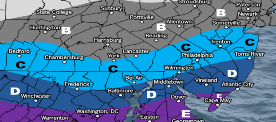
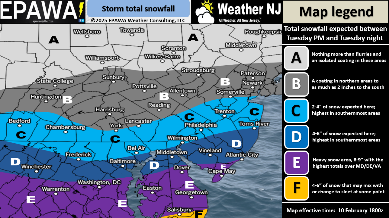
Here’s our snow impact map for snow occurring between 3pm Tuesday and 5am Wednesday:
On Wednesday, conditions will improve through late-morning/afternoon hours with temperatures coming up to the 32-40F range NNJ to SNJ. But clouds might hang around as another trailing system moves in for late-Wednesday night into Thursday morning. During this time, another snow-to-ice-to-rain situation is possible. CNJ and SNJ will likely stay too warm for such, but NNJ could see an additional 1-3”, maybe 2-4” of snow before changing to ice/rain. Focus will then turn to the Sunday Feb 16 and Feb 20 signals. But there’s no way we can touch those until Thursday. For now, all focus on the Tuesday-Wednesday snowstorm for CNJ/SNJ.
In English: It is going to snow between about 3pm Tuesday (tomorrow) and 5am Wednesday morning. It starts first in SWNJ/SNJ, makes it into NNJ by Tuesday night and then starts clearing around 3am Wednesday (completely out by 5am). The above map illustrates how much we think will fall and stick since all NJ areas will be below freezing at all critical layers in the atmosphere for snow making. SNJ should see the most amount of snow. NNJ should see the least. CNJ is in the middle as always but looking “just plowable” IMO. It’s not a big snowstorm but 6+ across SNJ is higher impact than across NNJ as it represents 1/3 to 1/2 of annual avg snowfall. With snow not starting until Tuesday afternoon, we have time for one more forecast tweak tomorrow morning if needed. But for now, this is our going forecast. Be safe! JC
Premium Services
KABOOM Club offers ad-free content, inside info forecast discussion, your questions answered, and early storm impact maps and video releases (ahead of the public). At two bucks per month, it’s an extremely feasible way to show additional support for Weather NJ. Think of it as a tip jar with perks. Available onFacebook or Patreon.
My Pocket Meteorologist (MPM), in partnership with EPAWA Weather Consulting, offers professional/commercial interests, whose businesses depend on outdoor weather conditions (snow plowing, landscaping, construction, etc.), with hyper-local text message alerts/forecasts and access to the MPM premium forum—the most comprehensive and technical forecast discussion available for PA and NJ.
Jonathan Carr (JC) is the founder and sole operator of Weather NJ, New Jersey’s largest independent weather reporting agency. Since 2010, Jonathan has provided weather safety discussion and forecasting services for New Jersey and surrounding areas through the web and social media. Originally branded as Severe NJ Weather (before 2014), Weather NJ is proud to bring you accurate and responsible forecast discussion ahead of high-stakes weather scenarios that impact this great garden state of ours. All Weather. All New Jersey.™ Be safe! JC


LOCAL FORECAST | INTERACTIVE RADAR | LATEST NJ WEATHER ALERTS | WEDDING FORECAST| PRIVACY POLICY
© Copyright 2025 Weather NJ LLC. All Rights Reserved.
Some information that can be found on our website is provided by a private weather station and is not an officially recognized station for weather reporting. Though we always strive to achieve accurate reporting for our own use, it is important that you do NOT depend on the data provided here for any purpose.
