

Clipper Snow Developing for Friday PM
Discussion: At the upper levels, the 250mb-observed jet carves out a trough pattern for the E US through the rest of this weekend. 500mb geopotential height analysis indicates a pure polar N stream energy phasing into a S stream trough developing over the SE US. The two phase together too late to produce something major for NJ. But it sends a clipper through and puts NJ on the W side of the larger-formed trough under cross polar Arctic flow.
At the lower-mid levels, the N stream system has its own low with cold front attached. It’s just like a frontal system that comes across the US (from W to E) that typically brings a warm sector, frontal passage, and cold sector after the cold front. Only in this case it comes from the N. The warm sector is not warm enough to cause rain. The frontal passage is an Arctic cold front, and the cold sector behind it is some of the coldest air of the N hemisphere. So, the low of the N stream system (that the Arctic front is attached to) will track across the Great Lakes into N NY State Friday afternoon/evening. This will drag the Arctic front through NJ between about 5pm and midnight Friday night. A 3-4 hour period of precipitation is expected along and just ahead of the front.
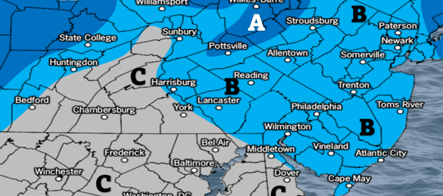
Friday snow (the clipper) should 1) Be on the fluffy side. Surface temps will be about 24-27 during snowfall with a very cold air column aloft. This should produce snow ratios of ~15:1 or greater (snow inches to liquid inches). In this case a tenth of an inch of liquid would produce 1.5 inches of snow. Two tenths of an inch of liquid would produce 3 inches of snow, etc. 2) Reduce visibility at times. Snow should be squally over a few hours with hard bursts at times, not a prolonged steady light snow. 3) Move into NWNJ any time after 4pm Friday and depart SENJ around midnight or just after. Somewhere within that 4pm-mignight grand timing window will be the 3-4 hour period of snowfall. NWNJ first, SWNJ/CNJ/NENJ more towards the middle and SENJ last. Note that lighter flurries could linger some into mid-to-late Saturday morning.
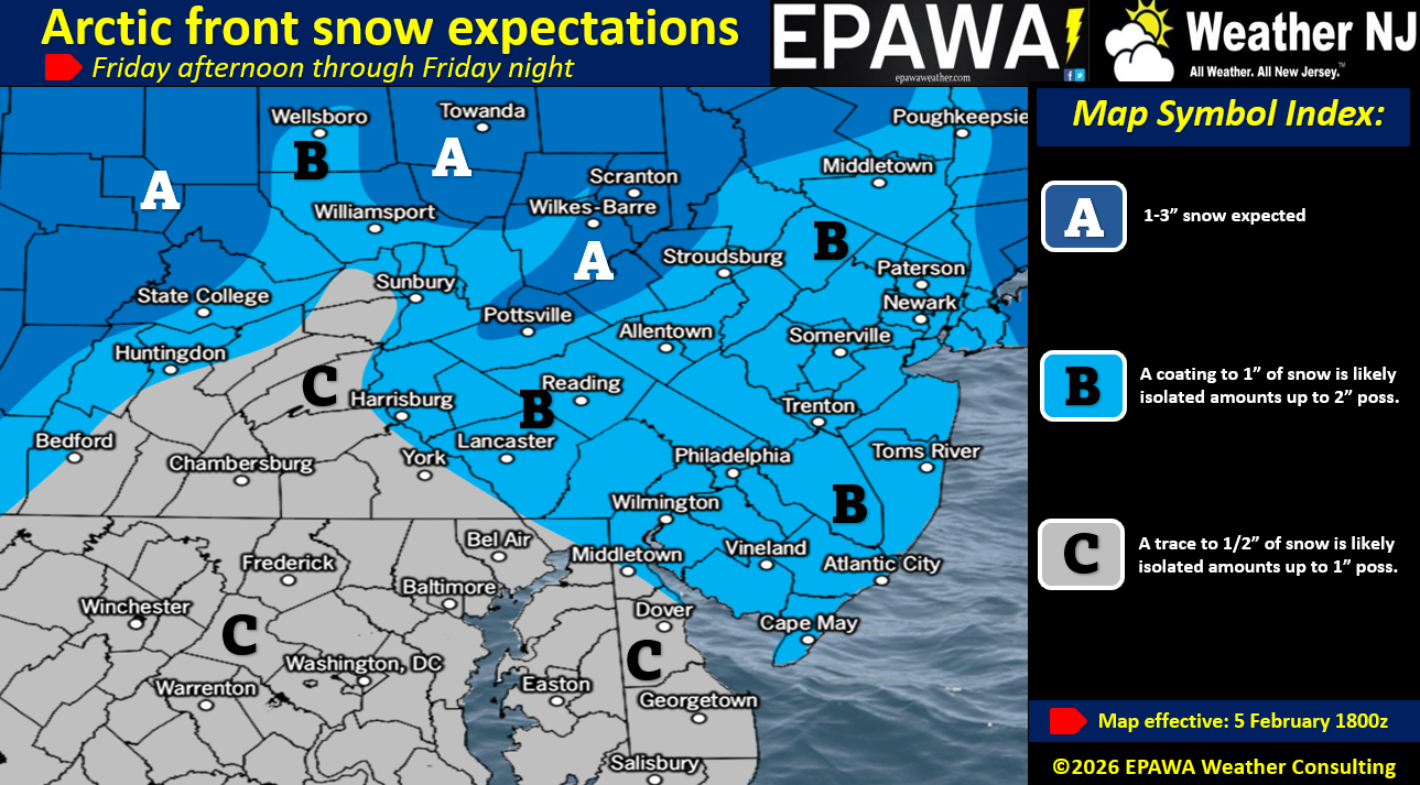
The clipper is then expected to transfer to an offshore location to the E of NJ and rapidly deepen on Saturday. At the same time, a high will locate to the W of NJ. The cyclonic flow from the low and anti-cyclonic flow from the high will team up to produce a tight pressure gradient running N to S over NJ. This will produce high winds with aggressive Arctic cold air advection on Saturday-Saturday night. It might be Sunday morning before winds subside. With that said, Saturday is going to be very cold and the northerly high winds will make it feel much colder. For all of these reasons, we’ve created three maps for you: Snowfall amounts Friday PM (afternoon) into Saturday AM (~sunrise), expected wind gusts in mph and then expected wind chill factors:
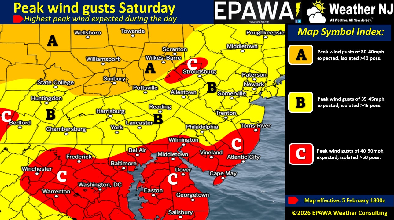
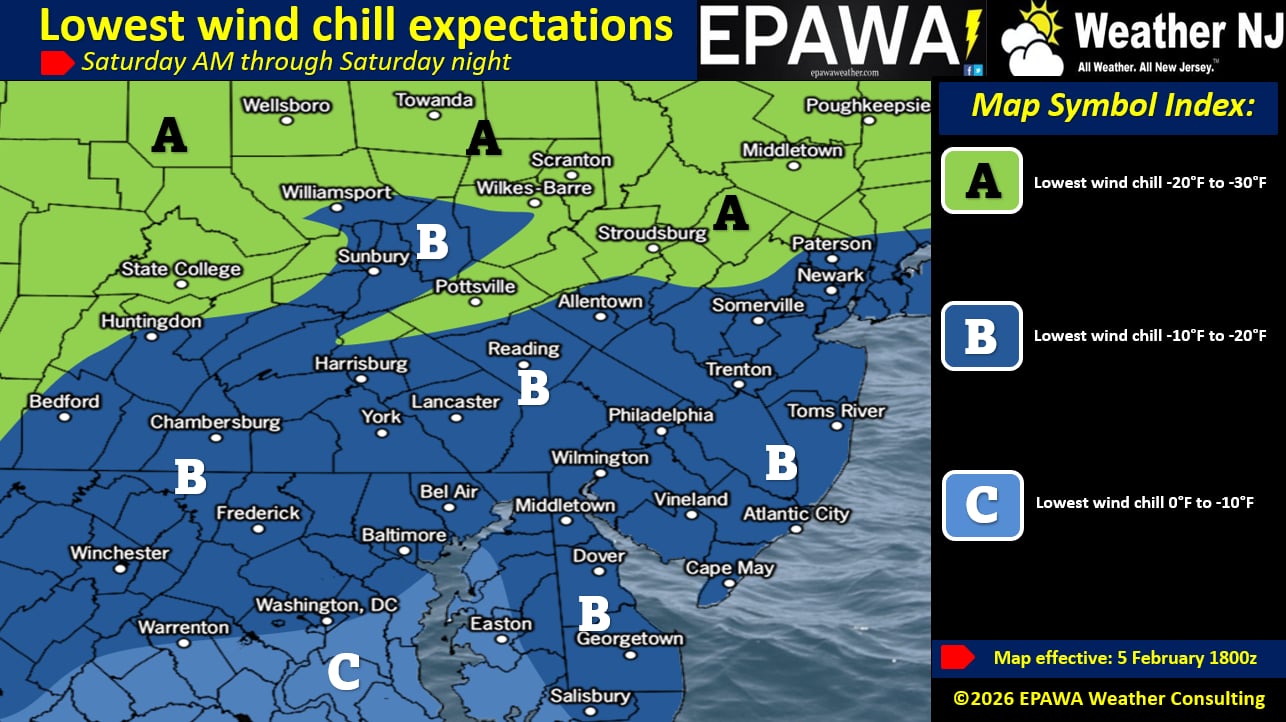
So Saturday night into Sunday should feature the coldest feeling temperatures due to the high N winds and wind chill factor. However, Sunday night into Monday could feature the lowest actual temperature as winds subside under clear skies and radiational cooling occurs. We’re in for a few more Arctic cold days which could fall to the coldest actual temperatures yet this winter…which is a bold statement after the last half of January and general below-average temperatures since Thanksgiving.
Moving beyond this weekend, we are monitoring a snow signal Wednesday night into Thursday morning (Feb 11-12 – not as cold of a system) as well as a signal next weekend (Feb 14-15). Both just long-range signals to monitor for now. We would start to take the Feb 11-12 signal seriously on this Saturday and the Feb 14-15 signal serious on Monday if they are still showing.
In English: A coating to an inch or two of snow is possible between Friday late-afternoon and early Saturday AM (most falling Friday night). Saturday into early next week then looks dry but very cold. High N winds on Saturday/Saturday night/Sunday morning will contribute to very low wind chill factor temperatures. On Tuesday, we’ll turn not as cold but we’re watching Wed-Thurs (Feb 11-12) and then the weekend (Feb 14-15) for long-range signals capable of producing more snow. Live tracking will begin on first flakes tomorrow (Friday) entering NWNJ. Be safe! JC
Premium Services
KABOOM Club offers an ad-free environment, inside info (Above and Beyond) forecast discussion, your questions prioritized, and early storm impact maps and video releases (ahead of the public). At $1.99 per month, it’s an extremely feasible way to show additional support for Weather NJ and you can turn it on and off for however many months you wish. Think of it as a tip jar with perks. Available onFacebook or Patreon.
My Pocket Meteorologist (MPM), in partnership with EPAWA Weather Consulting, offers professional/commercial interests, whose businesses depend on outdoor weather conditions (snow plowing, landscaping, construction, etc.), with hyper-local text message alerts/forecasts from real meteorologists and access to the MPM premium forum—the most comprehensive and technical forecast discussion available for PA and NJ commercial interests.
KABOOM Shop is live if you want some KABOOM or Weather NJ Merch!
Sign up for ZoneWatch Radar and get 10% off
Jonathan Carr (JC) is the founder and sole operator of Weather NJ, New Jersey’s largest independent weather reporting agency. Since 2010, Jonathan has provided weather safety discussion and forecasting services for New Jersey and surrounding areas through the web and social media. Originally branded as Severe NJ Weather (before 2014), Weather NJ is proud to bring you accurate and responsible forecast discussion ahead of high-stakes weather scenarios that impact this great garden state of ours. All Weather. All New Jersey.™ Be safe! JC


LOCAL FORECAST | INTERACTIVE RADAR | LATEST NJ WEATHER ALERTS | WEDDING FORECAST| PRIVACY POLICY
© Copyright 2026 Weather NJ LLC. All Rights Reserved.
Some information that can be found on our website is provided by a private weather station and is not an officially recognized station for weather reporting. Though we always strive to achieve accurate reporting for our own use, it is important that you do NOT depend on the data provided here for any purpose.
