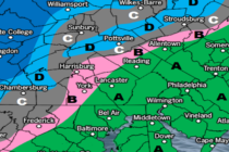
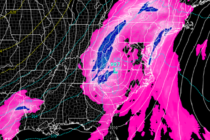
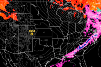
Coastal Storm Departs
Discussion: The upper low that got caught beneath the ridge for the past few days is finally starting to pull away. This will place the western side of the cyclonic steering flow from the upper low over the surface low
Discussion: I’m seeing some intense coastal flooding images coming in from locations like LBI, Brigantine, etc. It’s not good considering high tide is approaching and these new rain bands will have nowhere to drain. It looks like there will be
Discussion: Ian’s span of impact is incredible. From the Caribbean, through Cuba, through Florida, into South Carolina, interior SE US, etc. And now, it’s going to fart kick us as it heads away from the east coast. As I discussed
Discussion: The upper jet, observed at 250mb, is departing away from the NE US (to the E). The upper-level low energy associated with Ian’s remnants will now hang back and sit over the coastal Mid-Atlantic US until about Wednesday before
Discussion: This weekend’s outlook is going to stay in the form of a discussion article since conditions will be mostly determined by Ian’s remnants. Ian made a second landfall today in coastal SC (N of Charlston S of Myrtle Beach)
Discussion: Ian made landfall yesterday in the Punta Gorda area of Florida as a category 4 major hurricane. You’ve probably seen images and footage of such. Pretty much a worst-case scenario for the central western FL coast. Overnight, Ian crossed
Discussion: Ian is a major category 4 hurricane (just short of category 5) an will likely make landfall on the central W FL coast this afternoon-evening. It looks like the area between Sarasota/Tampa and Sanibel Island represent the location of
Discussion: Before discussing New Jersey impacts, let’s get up to date on Ian’s current situation. Ian’s eye has just emerged into the SE Gulf of Mexico after passing over W Cuba this morning. Ian will now try to follow the
Discussion: The current upper level setup is something a snow lover would want to see in the winter months…a ridge over the W US and a trough over the E US. The trough should drift/swing eastward between now and Thursday
Discussion: I’m going to cover two topics today. First will be the approaching frontal system with immediate impacts to NJ this evening/tomorrow morning…and what that will set up for much of this week. Then we’ll cover Ian. Rain and thunderstorms