Pre-Christmas Storm Update
Discussion: I wanted to give it through 00Z model data tonight, at least to the GFS run, to confirm the trend that has occurred this weekend and what it means for the December 22-24 storm signal. It’s bad news for


Discussion: I wanted to give it through 00Z model data tonight, at least to the GFS run, to confirm the trend that has occurred this weekend and what it means for the December 22-24 storm signal. It’s bad news for

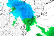
Discussion: The current system is pulling away to the NE. Behind it, we’re left with colder and drier W/NW flow at the surface (NW flow aloft). The temp and dew point should peel away from each other with a significantly

Discussion: The current system today should begin tapering off for SNJ after midnight tonight. It will continue to taper from SW to NE and will take longer for CNJ and then ultimately NNJ by later tomorrow. Most areas should clear
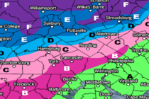
Discussion: Just a few small tweaks to a final forecast heading into the Thursday-Friday event that we’ve been tracking. Yesterday’s article covered all the principal dynamics involved and those have not changed: Primary low cuts into the Great Lakes, encounters
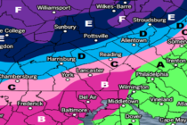
Discussion: We’re now close enough to suggest a forecast for Thursday-Friday. We’ve watched this superblock linger near Greenland for a while now. This block will likely be located to the S of Greenland this Thursday-Friday. A primary surface low will
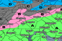
Discussion: Precipitation is currently moving in from the W/NW. A snow/rain line is forming somewhere between I-80 and I-78 on the W side of NJ. This should extend over into NENJ but likely NW of I-95/NJTP. Precipitation should fall on-and-off
Discussion: Real quick, most areas should fall into the upper-20s/lower-30s tonight. This should end the very mild conditions we saw this week. I know I have been eyeing up the Dec 11-17 period for favorable snowstorm development conditions in prior

Discussion: The anomalously high (geo heights) ridge has formed and is still expected to meander around/over Greenland until at least Dec 17th. We’re going to see a milder week this week as heights actually build up the E US coast

Discussion: While forecasters continue to drool over the anomalous blocking signal expected to begin next week, let’s stay focused on what’s in front of us this weekend. A ridge will build over the Northeast US today (Friday) before handing off
Discussion: The primary low in Canada is down to 978mb. Isobars are tightening and the attached cold front drapes all the way down into the SE US. High pressure is materializing over Oklahoma and will soon drift eastward, reinforcing the

LOCAL FORECAST | INTERACTIVE RADAR | LATEST NJ WEATHER ALERTS | WEDDING FORECAST| PRIVACY POLICY
© Copyright 2025 Weather NJ LLC. All Rights Reserved.
Some information that can be found on our website is provided by a private weather station and is not an officially recognized station for weather reporting. Though we always strive to achieve accurate reporting for our own use, it is important that you do NOT depend on the data provided here for any purpose.


