Very Warm for Mid-April
Discussion: High pressure over the E US is drifting eastward out to sea. Behind that, the upper jet is going to set up way N and over NJ (into Canada) forming an E US ridge that should dominate the weather


Discussion: High pressure over the E US is drifting eastward out to sea. Behind that, the upper jet is going to set up way N and over NJ (into Canada) forming an E US ridge that should dominate the weather
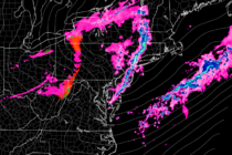
Discussion: As expected, today is the warmest day of the week. We have high pressure near Bermuda pumping return flow into New Jersey from the S/SW. And we have an approaching cold front attached to a low tracking through SE

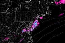
Discussion: That was a rough Saturday. I didn’t like the feel of it all day. The clearing we had between rain ending late-morning and the storms arriving early-evening felt uncomfortably mild and destabilized. It allowed the sun to heat the
Discussion: A very temporary ridge is currently over the E US correlating with S/SW flow at the lower levels. That’s why much of NJ is still in the 50s at 11pm. Some even in the lower-60s. It’s going to remain

Discussion: High pressure will cross over NJ from NW to SE between today (Thursday) and tomorrow morning (Friday). Today/tonight’s chillier conditions are owed to the high’s front-side flow/northerly winds. Temps will hit their bottom tomorrow morning around 6am then rapidly

Discussion: New Jersey will stay under below-average height anomalies until about Thursday night (lower heights). This will allow for a cooler stretch (highs only reach lower-50s and drop into 30s at night – coldest day Thursday). A weak and unorganized

Discussion: The 250mb jet wants to stay N of NJ for the near-future with the exception of a small dip mid-next week. We’ll talk about that later. That should keep geopotential heights neutral or higher than average (weak ridging) with

Discussion: It looks like the upper-jet should push N of NJ from now through Saturday and establish a weak but unsettled E US ridge. High pressure, to the N of Bermuda, will track eastward today and tomorrow as a low

Discussion: The upper jet (250mb) should rage a bit, from SW to NE, over the Mid-Atlantic US this weekend. 500mb analysis indicates a deep upper-low tracking from the Great Lakes into SE Canada but in a very progressive trough with

Discussion: Of every 10 years, about 1-2 winters feature way-below average snowfall and in some cases a big goose egg. This winter was one of those. It was nice however to see parts of NNJ squeeze out some snow accumulation

LOCAL FORECAST | INTERACTIVE RADAR | LATEST NJ WEATHER ALERTS | WEDDING FORECAST| PRIVACY POLICY
© Copyright 2025 Weather NJ LLC. All Rights Reserved.
Some information that can be found on our website is provided by a private weather station and is not an officially recognized station for weather reporting. Though we always strive to achieve accurate reporting for our own use, it is important that you do NOT depend on the data provided here for any purpose.


