Nuisance Rain and Wind to Start
This weekend article proudly advertises a charity event that is close to my heart. It goes back over 10 years to a few of us setting up a Halloween maze in my buddy’s driveway. Since then it has grown into


This weekend article proudly advertises a charity event that is close to my heart. It goes back over 10 years to a few of us setting up a Halloween maze in my buddy’s driveway. Since then it has grown into

Discussion: The dreaded weekend rain pattern continues. I feel like this should be a Star Wars crawl. It was nice to see this past weekend’s system exit in time for a salvageable Sunday. Rain totals varied wildly as expected with
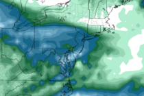
Forecast Discussion: Not much has changed since the article earlier this week. We have another weekend rain event as the weekend rain pattern continues. We have a Miller-B synoptic setup this weekend. A primary low (currently developing) will track from

Forecast Discussion: There seems to be a lot of interest in the rain this weekend. Seems we’ve gotten into a weekend rain pattern with weekdays featuring immaculate fall weather conditions. Ah well, it happens. This weekend doesn’t look too crazy

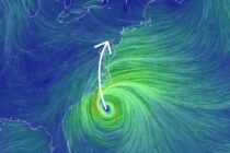
Discussion: We have another “trough meeting remnant tropical cyclone” situation this weekend for the E US however most action of interest will be for the Gulf of Maine and SE Canada. Post-Tropical Cyclone Phillippe is currently near Bermuda and is
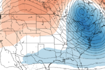
Discussion: This week, we have a solid transition from warmer to cooler conditions. The 250mb jet and 500mb height analysis indicates a well-defined ridge giving way to a deep trough. The ridge will dominate much of today through Friday with

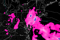
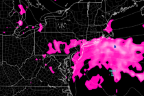
Discussion: The Inverted Trough (IVT) has done it’s thing and targeted NYC and surrounding areas (including NENJ/ECNJ) with the heaviest rainfall of the system. I’m seeing some pretty intense flash flooding imagery and videos coming out of NYC. Low pressure
Forecast Discussion: The system that began impacting New Jersey on Friday night (Sept 22) has finally cleared out (as of last night – Tuesday night). A very prolonged event originally initiated by tropical storm remnants and ultimately sustained as a
Storm Synopsis: Last week, a tropical disturbance formed a few hundred miles E of Florida. The upper low associated with the disturbance formed due south of an upper-level ridge centered over SE Canada. The ridge extended higher geopotential heights southward
Discussion: Today (Friday), I have a better idea about how this weekend should play out. With that said, the weekend outlook will be in article format today since we have an active system affecting the area through at least Monday.

LOCAL FORECAST | INTERACTIVE RADAR | LATEST NJ WEATHER ALERTS | WEDDING FORECAST| PRIVACY POLICY
© Copyright 2025 Weather NJ LLC. All Rights Reserved.
Some information that can be found on our website is provided by a private weather station and is not an officially recognized station for weather reporting. Though we always strive to achieve accurate reporting for our own use, it is important that you do NOT depend on the data provided here for any purpose.


