March 7: And That’s a Wrap
As the last remnant bands finish up in NENJ, I wanted to talk a bit about this storm. Another powerful March nor’easter has had heavy impact on New Jersey. This storm was not as large-scale as last Friday’s but it


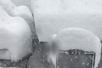
As the last remnant bands finish up in NENJ, I wanted to talk a bit about this storm. Another powerful March nor’easter has had heavy impact on New Jersey. This storm was not as large-scale as last Friday’s but it

Discussion: The storm center is now to the east of New Jersey. It should slowly begin to pull away from the coast to the NE. As this happens precipitation will shut off from SW to NE. I expect far-SW areas near the
Discussion: The storm center is now intensifying just off the Delmarva Peninsula. It should take a run towards the Cape May-Atlantic City area before pulling away from the coast a bit. The low is not expected to sit on the coast

Click here for full-resolution snow map! Click here for full-resolution snow map! Discussion: These late-winter storms are tricky. Let’s get the more confident areas out of the way first. Areas to the NW of I-95 are most likely to KABOOM (zones
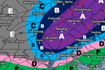
Click here for full-resolution snow map! Discussion: I know this map is busy so let me explain. The idea of jackpot accumulations occurring to the NW of I-95 is a fair assumption. That’s your most-likely Kaboom zone (zone A). The idea

Discussion: The blocking signal is still strong enough to impact approaching upper-level shortwaves coming in from Canada. A few shortwaves are expected to meander in from the W/NW in a “ring around the rosie” manner. Despite the incredible block, the approaching Pacific

It’s time to harness the WeatherTrends360 proprietary weather algorithms to see how the rest of March 2018 should play out. But first lets break New Jersey into climatological regions. We have the higher elevations of NNJ/NWNJ, the interior coastal plain (SWNJ through CNJ and

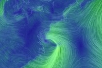
Discussion: The above modern satellite imagery shows the nor’easter pulling away from the E US. A tremendous mid-latitude cyclone! Southern coastal New England took the worst of it. New Jersey only dealt with secondary effects. NNJ elevations Kaboomed with snowfall
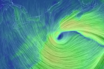
Discussion: The nor’easter has intensified to a 974mb low just S of Cape Cod. It is now taking small steps towards the NJ coast while ultimately moving S and away away to the S/SE towards Bermuda. Let’s take each weather condition at

Rain Map: Please click here for full-resolution rain map! Wind Map: Please click here for full-resolution wind map! Snow Map: Please click here for full-resolution snow map! Discussion: Two upper-level shortwaves will merge near the E Great Lakes area and form

LOCAL FORECAST | INTERACTIVE RADAR | LATEST NJ WEATHER ALERTS | WEDDING FORECAST| PRIVACY POLICY
© Copyright 2025 Weather NJ LLC. All Rights Reserved.
Some information that can be found on our website is provided by a private weather station and is not an officially recognized station for weather reporting. Though we always strive to achieve accurate reporting for our own use, it is important that you do NOT depend on the data provided here for any purpose.


