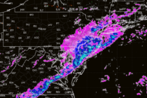
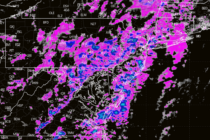
Insanely Nice Conditions
Discussion: The upper jet should stay to the N of NJ this weekend before crossing S over NJ briefly Tues-Wed and ultimately returning N of NJ by Thursday of next week. This will set the stages for an abnormally warm
Discussion: A shallow positive trough will meander over NJ for much of this week, producing colder temperatures with a slightly unsettled feel. The trough should then give way to a building ridge for the weekend, yielding milder conditions. In the
Discussion: We have a low tracking from the Great Lakes into SE Canada tonight (Thursday night). A cold front is attached to this low which should push a storm/cold front through NJ. Lightning is yet TBD but we’re at least
Discussion: A potent upper low has crawled across the US from W to E over the last few days…very dynamic with lots of vorticity and clashing air masses of varying temperature/moisture. At the lower levels, this has created quite the
Discussion: We’ll be in a split jet zonal pattern for this weekend into next, the N stream to the N of NJ and the S stream to the S of NJ…which is why there won’t be a phased snowstorm this
Discussion: This storm has certainly juked a lot of us forecasters around. In full and honest transparency, if I haven’t already made it clear, uncertainty is high with this. We’re dealing with specific phase timing required + a possible InVerted
Discussion: There’s a lot to talk about. I think it’s better to break it down by time period and hazard rather than by hazard type only. So, let’s start with right now and walk through next week. Today’s Snowy Burst:
Discussion: A weak low will ride the thermal boundary and drive into W PA from the TN area tomorrow (Saturday). Initial precipitation will crash into a wall of cold air at first and generate a front-end snowfall for most of
Discussion: We’re in the middle of a six, potentially seven, system onslaught. Three of them have passed, the two snow-to-ice-to-rain systems last week and last night’s CNJ/SNJ event. The next two (system #4 and #5) are also wintry-to-non-wintry systems and
Discussion: A wave will traverse the gradient thermal boundary from W to E today across the US and meet up with a weak coastal low off OBX Tuesday afternoon. The coastal low should enhance a flat/zonal precipitation shield of snowfall