Back to homepage

Latest NJ Weather Alerts

A Windy Wednesday Night Expected

A Windy Wednesday Night Expected

🕔22:23, 4.Nov 2025

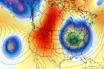
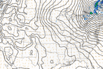
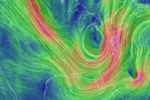
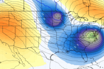
Discussion: A potent upper-level shortwave will graze through NNJ Wednesday night into Thursday morning. It’s not a trough or even an upper low, just a potent shortwave as seen below here in both 500mb geopotential heights and 500mb vorticity (solid

Read Full Article
First Wintry Signal to Track

First Wintry Signal to Track

🕔15:42, 3.Nov 2025

Discussion: We’re going to stay in article format for this week’s outlook since a very active pattern is setting up. I’m seeing low after low through mid-November. That doesn’t necessarily mean rain or snow for NJ with each of the

Read Full Article
A Hard Slap of Fall Feel

A Hard Slap of Fall Feel

🕔12:13, 31.Oct 2025

Discussion: Our rainstorm has ended regarding precipitation. All of NJ saw at least the .75 inch expectation. Much of WNJ just reached that. Parts of ENJ, especially NENJ, exceeded the 2 inch mark with some localized areas seeing between 2.5

Read Full Article
Rainstorm Approaching with Gusty Winds to Follow

Rainstorm Approaching with Gusty Winds to Follow

🕔17:16, 29.Oct 2025

Discussion: The E US trough formation is well underway. Luckily, Melissa will not be captured by it or else the east coast might have seen another Sandy-like scenario. If you’ve been following along, especially in Weather NJ premium areas, I

Read Full Article
Rainstorm Detected

Rainstorm Detected

🕔15:38, 27.Oct 2025

Discussion: With an anticipated rain event this week, we’re going to go article mode instead of weekly outlook. Today (Monday) was another day where skies were sunny as temps maxed in the 55-60 range…another beautiful fall today to add on

Read Full Article
Gorgeous Fall Conditions

Gorgeous Fall Conditions

🕔14:21, 24.Oct 2025

Discussion: At this point, I’m gaining confidence that Melissa will stay out to sea next week once she exits the Caribbean to the N into the Atlantic Ocean. However, Melissa could have a slight upper-level interaction with the system that

Read Full Article
Tracking a ~Halloween Storm Signal

Tracking a ~Halloween Storm Signal

🕔16:13, 23.Oct 2025

Discussion: We’ve been tracking a very long-range storm signal in our premium KABOOM Club areas for a little over a week now. This was identified earlier last week given multiple data sets and a supporting pattern of oscillation status. This

Read Full Article
Nice Fall Stretch Continues

Nice Fall Stretch Continues

🕔15:35, 20.Oct 2025

Discussion: The upper jet, observed at 250mb, should flow either over or to the S of NJ this week. This is due to a trough dominated pattern, observed at 500mb, which should close out October. This week should feel very

Read Full Article
A Much Better Weekend

A Much Better Weekend

🕔16:37, 17.Oct 2025

Discussion: The upper jet looks rather meridional as we bounce back and forth between trough, ridge and trough. The current trough is departing (responsible for the colder feel) as a weak but sufficient ridge builds this weekend and warms NJ

Read Full Article
Nor’easter Departs. Jersey Dries Out

Nor’easter Departs. Jersey Dries Out

🕔14:41, 14.Oct 2025

Discussion: The nor’easter is pulling away from the E US coast. Still some less intense coastal flooding potential from the general fade away radiative swell of the ocean system, along with the draining estuaries and back bays. But winds have

Read Full Article