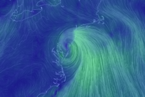
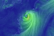
Hot Start (June 22-26)
Discussion: The upper-jet is pretty far N of NJ. I don’t need to tell you that the surface warm front is through. It should stay this way through Wednesday with NJ firmly planted in a warm sector. Sometime in the
Discussion: The upper-level low that broke off of last week’s trough has been churning over the interior S Mid-Atlantic/SE US for most of this week as expected. The ridge over SE Canada and NE US, however, has been obliterating the
Discussion: We’ve got an active upper-jet pattern in place for the next week or so. Cristobal’s remnants have formed a post-tropical cyclone in E Canada with a frontal boundary attached to it’s S. This frontal boundary is what currently moved
Discussion: The upper jet should stay to the N of NJ this week in a sea of ridging. The first part of this week features NW flow on the front of the ridge and the last-half, SW flow from the
Discussion: For tonight, we remain in a warm and muggy pattern mostly from the back-side return flow of high pressure near Bermuda. This flow has coupled with weak anticyclonic energy to our W to form W/SW flow across the Appalachian
It’s time to harness WeatherTrends360 technology and look at how the rest of June 2020 should play out. WeatherTrends360 algorithms are documented with an 84% verification rate and are based on oceanic water cycles, time table series and very complex
Discussion: We’ve had a warm front come through and that’s why today feels warmer and more humid. A cold front is expected to push through overnight tonight but that leaves a very warm and unstable environment today with the warm
Discussion: A NW upper jet should be nearby NJ for the foreseeable near future. We’re going to build a trough slowly between Saturday and Sunday which should flex Sunday-Tuesday before heights rise Wednesday-forward. High pressure has remained nearly stationary the
Discussion: Happy Memorial Day everyone! A moment of silence, appreciation and gratitude to those who have fallen to protect our amazing way of life… The upper-jet should stay to the N of NJ through at least Friday. This will correlate
Discussion: We currently have an upper level low over KY/TN weakening as it is colliding with strong ridging over SE Canada/NE US. It if fizzled out completely we would not have a worry about nuisance precipitation Friday-Saturday. But it does