Transitional Conditions
Discussion: First, a thank you to all who have served our country! A low pressure system has pulled off the upper-jet with an occlusion at the surface. As this low tracks from the Great Lakes into SE Canada, it will
Discussion: Low pressure is currently offshore but high pressure remains over NJ. A series of high pressure areas should produce a dry and comfortable Monday-Thursday this week. Mostly NW quadrant flow with lower dews but with a milder feel. Low
Discussion: We have some unorganized low pressure in the nearby Atlantic Ocean that should fail to reach the NJ coast this weekend. It might keep ECNJ/SENJ cloudier than the rest of NJ at times…or perhaps you might just see the
Discussion: A trough will spill into our region this week. The trough will have a positive axis with a progressive upper-level flow out of the W/SW for NJ. This flow will prevent any synoptic systems from wrapping up for our
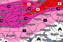
Discussion: The surface low is currently over the ~W Kentucky area and should continue to track NE up the Appalachian Mountain chain between now and Sunday morning. Conditions should deteriorate soon, especially for SNJ, as the leading edge of precipitation
Discussion: A second synoptic-scale weather system will impact NJ to start this weekend. Therefore, we’ll just go with a discussion article format as the general weekend outlook for now. I’ll likely update tomorrow ahead of the first drops and make
Discussion: Overnight lows should fall and then halt tonight (Sunday night) as S flow takes over. This could initially present some fog but otherwise should produce a milder feel for tomorrow (Monday). We’re going to see two areas of upper-level
Discussion: A mostly dry frontal passage came through overnight…a few sprinkles here and there. This has lowered temps and humidity some for today. Still a beautiful day today but tonight we’ll step down colder. The upper-level disturbance I’ve been tracking
Discussion: A rather boring upper level look this week. Most of the drivers are at the lower levels. High pressure is currently over ~SC producing NW for NJ. As the high slides E over the next few days, it will
Discussion: I apologize for being somewhat absent and distracted the last few weeks. I’ve been working on a very important presentation that I gave yesterday demonstrating the 4D weather visualization technology that my company has spearheaded me to develop. Yesterday,