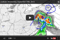
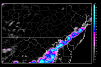
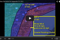
Sept 24: Wednesday NJ Forecast Video
Watch this Daily Weather Forecast Video covering the weather associated with our region, so you can start your day off right, by knowing what weather awaits you when you walk out your front door! Weather NJ
Short-range model guidance has come into agreement that a low pressure system will impact the east coast on Thursday. Moderate rain and gusty winds are expected. As far as exact timing goes, precipitation could start as early as Wednesday evening
Watch this Daily Weather Forecast Video covering the weather associated with our region, so you can start your day off right, by knowing what weather awaits you when you walk out your front door! Weather NJ
Currently there is an area of low pressure offshore and a cold front approaching from the W/NW. The coastal system looks to miss New Jersey completely but the front could bring some scattered showers this evening as it fizzles out
Today should be the last cooler day before we moderate for the weekend. Once the winds switch to a southwesterly direction, warmth and humidity will trickle back into the region to close out the weekend. Let’s look at each day:
High pressure has taken control of the mid-Atlantic US region and will continue to build throughout the entire week. The only day that rain seems possible is Tuesday from a very weak frontal passage. Otherwise, get ready for an Autumn-like week
Both Friday and Sunday are looking pretty good this weekend. Saturday however could fall victim to a low pressure disturbance moving through. This would specifically affect the New Jersey region with anything from overcast spotty drizzle to heavier rain showers, especially in the
The cold front has made it into western PA and will advance through our region this afternoon into evening. By tomorrow morning, the front should be out into the Atlantic Ocean with cooler and drier temperatures left in its wake.
A low pressure system will be moving from the Great Lakes region into E. Canada between now and tomorrow evening. Attached to the southern side of this system will be a frontal passage with showers and thunderstorms ahead of it.