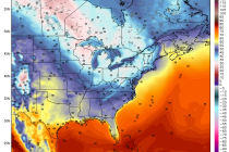
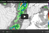
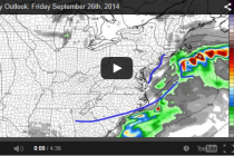
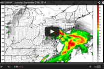
Back to homepage

Feature POST on Homepage

A cooler July continues (July 24-27)

A cooler July continues (July 24-27)

🕔12:53, 21.Jul 2014

It appears that the mini-warmup this week will be a transient occurrence. Temperatures will peak on Wednesday and precede a stormy evening-overnight. Once the cold front moves through on Thursday, temperatures will return to below-average. We’re talking about afternoon highs

Read Full Article
Humidity and storms return this week (July 21-25)

Humidity and storms return this week (July 21-25)

🕔20:58, 20.Jul 2014

This week we’re back to good ole fashion mid-summer weather. We can thank high pressure near Bermuda for making this possible by establishing a S/E ridge. Humidity will be returning as temperatures push higher and higher each day. By Wednesday

Read Full Article
July 20: Nuisance at the shore

July 20: Nuisance at the shore

🕔12:34, 20.Jul 2014

A weak area of low pressure is riding a stationary boundary about 200 miles offshore. High pressure is keeping this boundary out to sea but the overall conflict between high and low pressure is maintaining an onshore flow from the

Read Full Article
July 19: Where’s the sun?

July 19: Where’s the sun?

🕔12:31, 19.Jul 2014

The combination of high pressure to our north, high pressure near Bermuda, and a weak surface low pressure system forming off the SE US are resulting in onshore flow. This should persist today and into tomorrow which 9 times out

Read Full Article
Still watching Sunday rain (July 20)

Still watching Sunday rain (July 20)

🕔11:35, 18.Jul 2014

Today and tomorrow will continue to feature weather to die for. Highs will max out in the lower 80s with lows ranging from 58-64 (NWNJ-SENJ) under a mixed bag of mostly sun and clouds. I’m still monitoring Sunday for a

Read Full Article
Mixed Weekend Weather Ahead (July 18-20)

Mixed Weekend Weather Ahead (July 18-20)

🕔19:11, 17.Jul 2014

Thanks to the cooler air mass that’s in place, we should stay mostly dry and pleasant through at least Saturday evening. I’m watching a weak low pressure disturbance that might slide up the coast and bring rain showers to the

Read Full Article
Zero Tropical Activity? Learn Why

Zero Tropical Activity? Learn Why

🕔13:00, 17.Jul 2014

Atlantic Ocean surface temperatures are heating up. Latest buoy observations indicate a range of 68F near Long Island to 76F off the Delmarva Peninsula despite recent upwelling along the coast. We also have traditional high pressure tumbling between Bermuda and

Read Full Article
Back to School Weather? Already! (July 16-19)

Back to School Weather? Already! (July 16-19)

🕔10:33, 16.Jul 2014

With the invasion of an unseasonably cool air mass, that’s the best way I can describe the next few. Growing up I remember the specific feeling at the bus stop in New Jersey. Even though I knew it would it

Read Full Article
July 15: NJ Thunderstorms Moving In

July 15: NJ Thunderstorms Moving In

🕔17:53, 15.Jul 2014

The rest of New Jersey is about to get rocked with wind and rain.  Severe thunderstorms have downed trees and caused flash flooding along the I-95 corridor/northern coast since early afternoon. This is all now starting to push east thanks

Read Full Article
July 15: Damaging Storms Coming!

July 15: Damaging Storms Coming!

🕔12:50, 15.Jul 2014

Is everyone ready for another round of potentially damaging storms tonight? As I mentioned previously, this is a slow invasion of an unseasonably cool air mass pushing into a warm and humid air mass. The process started yesterday and will

Read Full Article