Jan 13: South Jersey Express Snow Detected!
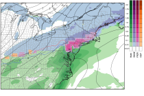
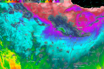
First, it’s my birthday today so let me say that this is a wonderful natural gift! Light snow in SNJ on Wednesday has been showing up on model guidance for the past 36 hours or so and it now looks
Temperatures this week should be pretty average for January, if not slightly above-average towards the end of the week. I’m still watching a low pressure disturbance that could impact extreme SNJ/SENJ on Wednesday morning but no major snow storms are
Just a few tweaks to the forecast/map but here’s my final call… Warmer air is surging northward in the mid levels of the atmosphere. The surface is holding on to colder temperatures at the surface longer. Precipitation starts as
I’m ready to make the following initial forecast for Monday’s winter storm: Tonight’s low temperatures will range from single digits in NWNJ to the teens in SENJ. Tomorrow temperatures stick their head above freezing during the day before falling back
There’s enough model support, in my opinion, to start getting ready for a winter event to start the week as early as late Sunday night. In tracking the evolution of next week’s weather pattern, here’s where we’re at right now.
High pressure, currently dropping out of Canada, will have full control of New Jersey this weekend. It will move through the Midwest US and pass just to our S into the Atlantic Ocean. This means generally dry conditions but not
Another clipper is approaching and next week’s winter storm possibility is still on the table. Let go right into detail. Current radar observations indicate snow showers and squalls moving through Ohio and approaching western PA. That puts it on the
Before we talk about the snow potential for next week we need to first look at this Friday. Another clipper system will be passing through—this time to our north. Short-range model guidance is indicating a lake-enhanced squall passing through New
Now that the clipper has moved through, very cold Arctic air will move in behind and keep temperatures well below-average starting tonight and heading into the weekend. The coldest moment of this Arctic wave appears to be early Thursday AM
A clipper system is riding the Arctic front heading straight for the mid-Atlantic US. This means light powdery accumulating snowfall tomorrow starting as early as sunrise in WNJ and as late as 9AM in ENJ. Clippers are generally fast movers