Dec 12: Very Cold Air Detected!
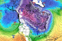
We’ve got some pretty cold air coming this Thursday and Friday. A few words of advice… First let’s get the science out of the way. A lobe of the polar vortex is going to swing through and bring very low


We’ve got some pretty cold air coming this Thursday and Friday. A few words of advice… First let’s get the science out of the way. A lobe of the polar vortex is going to swing through and bring very low
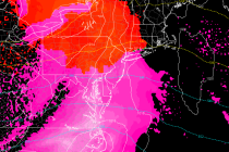
First, a quick update on the current wintry event. Then we’ll break the week down… The first batch of precipitation has moved through and is just leaving NENJ. Dew point temperatures were very cold/dry today, enough to evaporate most precipitation before
Yet another system with wintry potential for parts of New Jersey will move through tomorrow into Monday. Let’s break it down… Departing high pressure and low pressure tracking through the Great Lakes will attempt to drive warmer southerly flow into
The winter 2016-2017 season is here. My Pocket Meteorologist makes a great holiday gift for that weather nerd in your life. Just saying 8) Seriously though, find out why thousands have signed up… Eastern PA Weather Authority (EPAWA) has teamed

The Arctic front is moving in. Do you know where your mittens are? Disco: We’re now sandwiched between low pressure in SE Canada and the high pressure that dropped out of Canada into the Northwest/North-central US. This will set up
The incoming cold air is certain. In addition, a few snow possibilities are starting to show between now and Christmas. Let’s break it down… First let’s talk about the incoming cold air mass. This will be the coldest air of

Tuesday could feature moderate-to-heavy rainfall statewide and possibly more snow for the higher elevations of NWNJ. Let’s break it down… Low pressure is forming in the Gulf of Mexico and will track to the Ohio Valley. It should then transfer to
This week should remain cooler with mixed conditions but the true Arctic air mass arrives Friday. Let’s break it down… Disco: Once the Monday AM precipitation moves out, a quick moving area of high pressure should have control of the region
This will be the last forecast article for this system. Live observations from hereon out… Two weak systems are passing to our N and S but close enough to enhance precipitation through all of New Jersey overnight and into tomorrow morning.
We’ve got a light snow event approaching for parts of NNJ Sunday evening into Monday morning. Let’s break it down… Two waves will pass through our region from west to east. The northern energy will be in the form of

LOCAL FORECAST | INTERACTIVE RADAR | LATEST NJ WEATHER ALERTS | WEDDING FORECAST| PRIVACY POLICY
© Copyright 2025 Weather NJ LLC. All Rights Reserved.
Some information that can be found on our website is provided by a private weather station and is not an officially recognized station for weather reporting. Though we always strive to achieve accurate reporting for our own use, it is important that you do NOT depend on the data provided here for any purpose.


