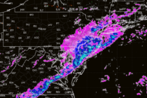
Back to homepage

Feature POST on Homepage

Snowstorm to Likely Graze SENJ

Snowstorm to Likely Graze SENJ

🕔17:03, 18.Feb 2025

Discussion: This storm has certainly juked a lot of us forecasters around. In full and honest transparency, if I haven’t already made it clear, uncertainty is high with this. We’re dealing with specific phase timing required + a possible InVerted

Read Full Article
Snowstorm Chances Increasing for Wed-Thurs

Snowstorm Chances Increasing for Wed-Thurs

🕔15:49, 15.Feb 2025

Discussion: There’s a lot to talk about. I think it’s better to break it down by time period and hazard rather than by hazard type only. So, let’s start with right now and walk through next week. Today’s Snowy Burst:

Read Full Article
Weekend Snow/Ice/Rain Storm Approaching

Weekend Snow/Ice/Rain Storm Approaching

🕔18:08, 14.Feb 2025

Discussion: A weak low will ride the thermal boundary and drive into W PA from the TN area tomorrow (Saturday). Initial precipitation will crash into a wall of cold air at first and generate a front-end snowfall for most of

Read Full Article
Active Pattern Continues

Active Pattern Continues

🕔14:22, 12.Feb 2025

Discussion: We’re in the middle of a six, potentially seven, system onslaught. Three of them have passed, the two snow-to-ice-to-rain systems last week and last night’s CNJ/SNJ event. The next two (system #4 and #5) are also wintry-to-non-wintry systems and

Read Full Article
CNJ/SNJ Snowstorm Developing

CNJ/SNJ Snowstorm Developing Updated

🕔16:55, 10.Feb 2025

Discussion: A wave will traverse the gradient thermal boundary from W to E today across the US and meet up with a weak coastal low off OBX Tuesday afternoon. The coastal low should enhance a flat/zonal precipitation shield of snowfall

Read Full Article
More Snow and Ice Approaching for Weekend

More Snow and Ice Approaching for Weekend Updated

🕔16:55, 7.Feb 2025

Discussion: Another slizzard lurks….a snow-to-sleet-to-freezing rain-to plain rain situation (depending on your NJ location) is expected tomorrow (Saturday) into Sunday morning. Here are the wintry impact maps and then we’ll break down the expectations by region again. PLEASE READ DON’T

Read Full Article
More Wintry Storms Detected

More Wintry Storms Detected Updated

🕔16:55, 6.Feb 2025

Discussion: Our first of the three storm signals has passed through, Parts of NNJ saw a coating to an inch of snow+ sleet but sleet was the dominant form of wintry precipitation before most areas went to plain rain. It

Read Full Article
Snow and Ice Storm Approaching

Snow and Ice Storm Approaching

🕔16:55, 5.Feb 2025

Discussion: There’s very little change in our forecast and maps issued yesterday for tonight (Wednesday night) into tomorrow (Thursday). So I am going to use this article opportunity to drill down on what to expect by NJ region. First, here

Read Full Article
Snow and Ice Storm Developing

Snow and Ice Storm Developing

🕔17:02, 4.Feb 2025

Discussion: High temperatures in NJ today ranged from about 38-53 N to S. The front-side of anticyclonic flow (N flow) associated with high pressure approaching from the W will drop temperatures much colder through sunset and into overnight hours tonight—bottoming

Read Full Article
Three Wintry Signals Detected

Three Wintry Signals Detected

🕔16:08, 3.Feb 2025

Discussion: We’re switching to storm tracking mode. This means article updates (likely daily) ahead of expected wintry events rather than the traditional weekly and weekend outlook articles (during boring nice weather times). I’m continuing to see a pattern, favorable for

Read Full Article