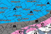
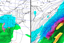
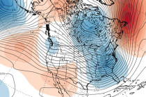
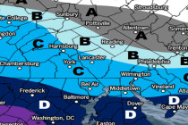
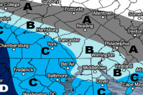
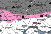
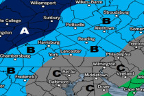
Jan 10: Light Snow Event Expected
Discussion: Low pressure will track across the SE US and eject into the Atlantic Ocean over OBX. From there it is not expected to turn up the coast and produce a major snow storm. Instead it will likely remain on
Discussion: Changes in the western Pacific ocean indicate a more active pattern from about January 20 and forward into February. It takes about two weeks for downstream-propagation for such changes to reach the E US. We’re not there yet, including this
Discussion: It’s no secret that last night was cold and temperatures have struggled to climb today. For the areas of expected wintry impact overnight tonight temperatures have failed to climb above freezing today. For the lower 2/3 of NJ temperatures are
Discussion: Tonight’s temperatures should bottom out pretty low. Monday should warm as light precipitation moves in for Monday night into Tuesday morning. There’s some wintry precip concern for NNJ as precip arrives Monday night. Everyone else should see all rain.
Discussion: A cut-off upper level low will track from Texas over Virginia into the Atlantic Ocean. A corresponding surface low will track just to the north of the ULL through Kentucky, Virginia and ultimately over New Jersey. The upper-level flow
It’s time to harness the WeatherTrends360 proprietary weather algorithms to see how the rest of January 2019 should play out. But first lets break New Jersey into climatologically-similar regions. We have the higher elevations of NNJ/NWNJ, the interior coastal plain and Newark Basin (SWNJ
Discussion: There is no point in sugar coating it. 2019 will end mild and wet and the first week or two of January also looks relatively mild. For those who dislike snow this should come as good news. For the
Discussion: Above-average upper-level geopotential height anomalies will continue to dominate the pattern today (Friday) and most of Saturday. Heights should relax into a transient zonal pattern for Sunday before rebuilding to start next week. This means mild and wet today
Discussion: An area of high pressure is departing the ~Maine area as low pressure cuts through the Great Lakes behind it. This should set up a warm sector rain event for most of Friday. The line of precipitation appears pretty thin
Discussion: The upper levels appear flat/zonal through this week and into the weekend. At the surface high pressure should slowly float through the E US from Monday through most of Thursday. That should keep temps near-average under dry conditions. I