The Heat is On!
Discussion: First, an acknowledgement to those who have bravely fallen for our country. I hope everyone had a great weekend and enjoyed all that the fought-for freedom allows us to. It’s now go time for the warmer months of the


Discussion: First, an acknowledgement to those who have bravely fallen for our country. I hope everyone had a great weekend and enjoyed all that the fought-for freedom allows us to. It’s now go time for the warmer months of the
Discussion: As someone vested in outdoor BBQ interests this weekend, like many of you, I’ve been monitoring this weekend’s weather forecast like a hawk. At first (from fantasy range) there was a potential hurricane capable of bringing remnants up the

Discussion: We’ll be under ridging for most of this week. A little cooler earlier in the week with the onshore flow associated with high pressure to our N. That high will then move offshore and help bring a warm front

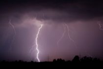
Discussion: Thunderstorms associated with a Mesoscale Convective Vortex (MCV) are approaching NJ from the W. NENJ and ECNJ look a bit more stable but NWNJ and most of SNJ are baking in instability today. The NWS has a tornado watch
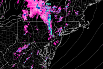
Discussion: A quick glance at the radar indicated that the storm front is knocking on NWNJ’s door. A few smaller cells have formed today for NJ, ahead of this storm front, but were non-severe and ended up fading out. The

Discussion: The bottom of a trough will swing through the Mid-Atlantic US tomorrow (Monday). That’s going to put a strong upper-jet over New Jersey in close timing with the end of peak diurnal surface heating from the sun. It should

Discussion: The annoying low pressure system, that tracked a loop from just SE of NJ (last weekend’s storm), towards Bermuda earlier this week, the backwards towards the SE US (last few days), is now coming up the coast as disorganized

Discussion: That was some crap weather this past weekend. Hopefully Sunday worked out for as many possible but wow at Friday-Saturday. There will be two noticeable themes this week. One is a gradual warming from Monday into the weekend. The
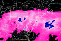
Discussion: The cause for this weekend’s rain and wind storm is an upper low drifting across the E US between now and early next week. During this time, a few areas of concentrated low pressure will organize at the surface

Discussion: A slow moving upper-level low will drift across the Mid-Atlantic US from W to E this weekend (arrives Friday departs Sunday). An associated weak surface low will flow beneath, bringing rain and wind to New Jersey for at least

LOCAL FORECAST | INTERACTIVE RADAR | LATEST NJ WEATHER ALERTS | WEDDING FORECAST| PRIVACY POLICY
© Copyright 2025 Weather NJ LLC. All Rights Reserved.
Some information that can be found on our website is provided by a private weather station and is not an officially recognized station for weather reporting. Though we always strive to achieve accurate reporting for our own use, it is important that you do NOT depend on the data provided here for any purpose.


