Unsettled but Summery
Discussion: It looks like the upper jet will stay N of NJ until later next week. The tip of a weak trough to our N will allow a drier Friday night into Saturday morning. As a surface low moves out


Discussion: It looks like the upper jet will stay N of NJ until later next week. The tip of a weak trough to our N will allow a drier Friday night into Saturday morning. As a surface low moves out
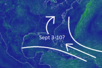
Discussion: For the immediate future we’ll generally stay warm, humid, and slightly unsettled through about Wednesday of next week. Model consensus has consistently suggested a break in the pattern starting next Thursday which would produce stellar conditions for Labor Day

Discussion: A disturbance is rotating through, mainly drive by a low tracking through NY State and some lowering pressure just offshore of NJ. This provided enough lift for overnight thunderstorms and will continue to do so until Tuesday. By Tuesday

Discussion: The upper-jet looks mostly over NJ this weekend before it fizzles out and reestablishes to the N of NJ next week. Heights and flow look zonal in the upper levels which means rather uneventful conditions for the near future.

Discussion: The upper-jet has dipped S of NJ and might stay this way until about Saturday night. This will keep NJ in an area of lower geopotential heights until the jet returns northward by Sunday. We’ll have a more organized

Discussion: Today’s (Thursday) temperatures should max in the 80s, maybe some approaching 90, with a continued humid feel. Showers are possible here and there, much like a tropical environment, but the true relief starts tomorrow (Friday). There might be some

Discussion: Most of NJ is nearing 90 if not just over. Immediate ECNJ/SENJ coastal areas are ranging 70-80 with 80s just inland. Seeing some sea breeze front induced storm cells popping in coastal N Ocean County. Can probably expect this

Discussion: Except for the immediate ECNJ/SENJ coast, the rest of NJ is currently in the 90s and still has a few degrees to climb until we peak out around 3-3:30pm today (Thursday). The humidity is back, and it feels like

Discussion: A weak disturbance brough clouds and light rain through overnight and today but that’s pushing further offshore now (Monday afternoon). We’ll gradually improve tonight before SW flow resumes for the region and sends us back into a hot and

Discussion: The upper-jet will be nearby tonight (Friday) before retreating back to the N for the rest of the weekend and next week. Upper-level flow appears zonal until a weak ridge likely develops by Sunday night to set the stage

LOCAL FORECAST | INTERACTIVE RADAR | LATEST NJ WEATHER ALERTS | WEDDING FORECAST| PRIVACY POLICY
© Copyright 2025 Weather NJ LLC. All Rights Reserved.
Some information that can be found on our website is provided by a private weather station and is not an officially recognized station for weather reporting. Though we always strive to achieve accurate reporting for our own use, it is important that you do NOT depend on the data provided here for any purpose.


