Here’s what you should know about this holiday weekend.
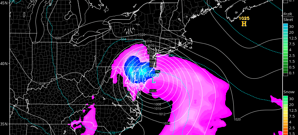
Tropical Storm Hermine is strengthening in the Gulf of Mexico N of the Yucatan Peninsula. There is evidence that Hermine has made the turn from westward movement to northward movement. This is narrowing the projected landfall track to an area between Pensacola and the big bend area with the Apalachicola area splitting the uprights. The system would likely then head up the east coast and miss the upper-level trough connection. After a possible extratropical transition (loss of warm core), the system could then impact the region during Labor Day Weekend as early as Saturday afternoon. I’m still uncertain as to whether impacts will end as early as Sunday evening or as late as early next week given today’s trend towards a longer duration event. An extratropical transition would help spread out the higher winds within the diameter of the system.
Intensification is expected between now and landfall sometime Thursday night/Friday morning. Notice, how the landfall timing has gone from Wednesday to Thursday and now including Friday morning? This is because the system has remained weak and was allowed to drift further W before turning.
This should present very rough conditions for the NW gulf coast, especially the area that sees the right front quadrant of the system (highest winds). The impact breakdown is expected as follows…
Florida Impacts: W Florida is already taking a convective band of thunderstorms to the face. Hermine should at least reach a strong tropical storm intensity, possibly hurricane strength before making landfall between Pensacola and the big bend Thursday PM-Friday AM. Areas Tampa and N through the Apalachicola area should experience the highest winds and highest coastal flooding levels. In addition 5-10 inches of rainfall are possible and there is a new moon. It all adds up to flooding taking the headline, not the wind. The system should then clear the landfall area by Saturday morning. Florida Wildcard: Given the shear between the S flow at the surface and the SW flow at the mid-to-upper levels, Florida has a decent chance of tornadoes occurring during impact. There is no way to predict where in Florida this will be. Such will have to be identified in real-time.
SE US Impacts: Between Friday and Saturday, the system should move up the coast, anywhere between a slightly inland or slightly offshore track. It now appears that more of the interior SE US will see at least rain and some wind from this. Coastal conditions should be hazardous along coastal Georgia, S Carolina and N Carolina during these days. While winds could still be high (up to 60mph), I also think rain and flooding will be the headline for this area.
New Jersey and Mid-Atlantic US Impacts: Winds should begin picking up on Saturday afternoon. Tides should be noticeably up as well. We should at least expect a period of rain between Saturday night and Monday morning. That window could be longer if there is more of a stall with the system. I think coastal flooding and heavy rainfall will be the headline here as well. Winds could be anything from just moderate (35-40mph) to high (up to 60mph). The final track through the east coast will determine this.
In English: After some scattered light showers and storms move through overnight tonight, a pleasant air mass will fill the region for Thursday, Friday and some of Saturday. Winds should pick up by Saturday afternoon with rain and higher winds moving in from the S overnight into Sunday, associated with Hermine. This should create a prolonged period of onshore flow which could last through several high tides. At least moderate coastal flooding is likely for these high tides. Winds could be moderate to high but rainfall and flooding should be the biggest story with this system. I still don’t know if this is going to be more of an interior track through the EC or more of a coastal track with a westward retrograde. These details should be ironed out by tomorrow evening. I’ll make another video for that analysis. Have a great night and be safe! JC
Jonathan Carr (JC) is the founder and sole operator of Weather NJ, New Jersey’s largest independent weather reporting agency. Since 2010, Jonathan has provided weather safety discussion and forecasting services for New Jersey and surrounding areas through the web and social media. Originally branded as Severe NJ Weather (before 2014), Weather NJ is proud to bring you accurate and responsible forecast discussion ahead of high-stakes weather scenarios that impact this great garden state of ours. All Weather. All New Jersey.™ Be safe! JC
