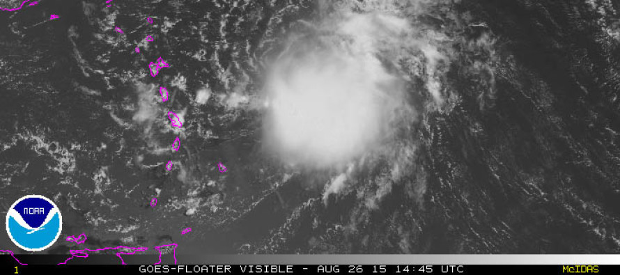
Erika has slightly intensified overnight and this morning. The big question is “How will this impact the US east coast?” Well, the Bahamas and Florida, as stated yesterday, should begin taking Erika seriously. We’re still a ways out and model guidance is notorious for trending between the transition of long-range to mid/short-range model guidance but as of right now, the National Hurricane Center is suggesting a Miami landfall between Sunday night and Monday.
While this makes sense at this time and is likely the best scientific-based projection right now, changes to this forecast are almost guaranteed as mother nature practices and executes chaos at all times. I do think however that we’ll have a much more confident handle on Erika’s track after observing land interaction with the northern Caribbean islands. The higher elevations of Hispaniola are known to shred apart tropical cyclone energy and there’s still some shear that Erika will encounter before moving into a favorable Bermuda Triangle region for development. Once we’re at that point, upper-level steering dynamics include influence from the Bermuda high as well as a deep digging trough moving across the US. Think of an asteroid passing between the gravitational field of two planets. The slightest deviation could mean tremendous difference in final track and impact. We’re simply too far away to call Erika’s behavior beyond an intensifying tropical storm in the Bahamas.
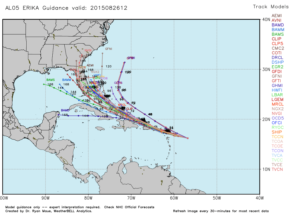
Right now, Erika is only producing 45mph sustained max winds and a minimum low pressure of 1005mb. There are healthy signs of convection and better circulation displayed since yesterday when Erika sightly weakened. The idea here is that the stronger Erika becomes, the more she will curve out to sea when nearing the SE US coast. The weaker Erika becomes, the more she will stay southward and possibly only threaten southern Florida. Here’s the latest tropical spaghetti plot of all current models plotted on a single map, used with permission from WeatherBell Analytics:
From this point on I expect a slow and gradual intensification with a track slightly north of the northern Caribbean islands. Once into the Bermuda Triangle, Erika will intensify more aggressively, likely into hurricane status, and threaten everyone from Florida to OBX. I give it a 60% chance of re-curve out to sea SE of OBX, a 10% chance of a weaker storm (remnants) into the Gulf, and a 30% chance of riding up the east coast bringing impacts north of OBX. New Jersey should at least expect some heavy surf and dangerous rip tides next week. Hopefully that’s it but I’m not confident enough to take higher New Jersey impacts off the table just yet. For now, tropical storm impact in the northern Caribbean and Bahamas is all but certain. Florida impact is becoming likely in the Aug 31-Sept 3 time period. I’ll be watching. Be safe! JC
Jonathan Carr (JC) is the founder and sole operator of Weather NJ, New Jersey’s largest independent weather reporting agency. Since 2010, Jonathan has provided weather safety discussion and forecasting services for New Jersey and surrounding areas through the web and social media. Originally branded as Severe NJ Weather (before 2014), Weather NJ is proud to bring you accurate and responsible forecast discussion ahead of high-stakes weather scenarios that impact this great garden state of ours. All Weather. All New Jersey.™ Be safe! JC

LOCAL FORECAST | INTERACTIVE RADAR | LATEST NJ WEATHER ALERTS | WEDDING FORECAST| PRIVACY POLICY
© Copyright 2025 Weather NJ LLC. All Rights Reserved.
Some information that can be found on our website is provided by a private weather station and is not an officially recognized station for weather reporting. Though we always strive to achieve accurate reporting for our own use, it is important that you do NOT depend on the data provided here for any purpose.


