Aug 20: Heavy Rainfall Approaching!

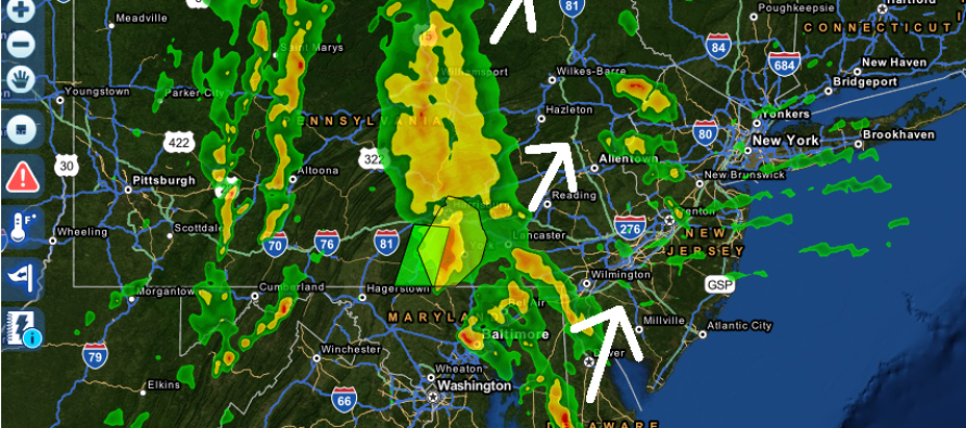
Several bands containing heavy rainfall and thunderstorms have formed to our W/SW and are approaching New Jersey. The cold front is just arriving at the Pittsburgh, PA longitude and will continue to advance towards New Jersey overnight and into the weekend. Until that front passes through, New Jersey is subject to warm and moist southerly flow which should allow for on-and-off downpours at any time.
Weak low pressure in the ocean is providing onshore flow at the surface which is feeding into the main driving low pressure disturbance over the N. Great Lakes. This is why you are seeing the lower clouds float in off the ocean while the upper level clouds move from SW to NE. A pre-frontal trough ahead of the cold front should assist in wringing out the tropical air mass overhead in the form of convective bands of precipitation. Precipitable water values (PWAT) are ranging from 1.5-2.2 which no doubt spell tropical downours when the sky decides to open up over you.
The low in the Atlantic has done a great job of pulling drier air down and counteracting the saturated Gulf of Mexico air mass that has been rising northward. The result, although feeling sticky, is a beautiful display of late-summer tropical skies and cumulus clouds.
So what does this mean? Expect heavy downpours this afternoon and evening through tomorrow morning but not continuous. There will be alternating periods of sun (stars overnight), clouds, and rain all of which will feel like a tropical jungle until the cold front clears. Rainfall this afternoon-evening should favor western parts of New Jersey while overnight rainfall should favor eastern parts of New Jersey. The weekend looks somewhat okay except for coastal regions who could see increased clouds and light shower remnants if the front doesn’t clear all the way. The main idea is that the cold front will slow down as it approaches. I’ll touch more on this in the weekend outlook this evening. Stay dry and be safe! JC
Jonathan Carr (JC) is the founder and sole operator of Weather NJ, New Jersey’s largest independent weather reporting agency. Since 2010, Jonathan has provided weather safety discussion and forecasting services for New Jersey and surrounding areas through the web and social media. Originally branded as Severe NJ Weather (before 2014), Weather NJ is proud to bring you accurate and responsible forecast discussion ahead of high-stakes weather scenarios that impact this great garden state of ours. All Weather. All New Jersey.™ Be safe! JC


