Discussion: The center of the approaching system is actually in SE Canada which is producing a large mid-latitude cyclone for much of E North America. For NJ, we’ll see the southern side of it in the form of a cold front with low pressure riding the cold front. Our low is just getting started near Florida and will track up the coast between now (Wednesday PM) and Friday AM.
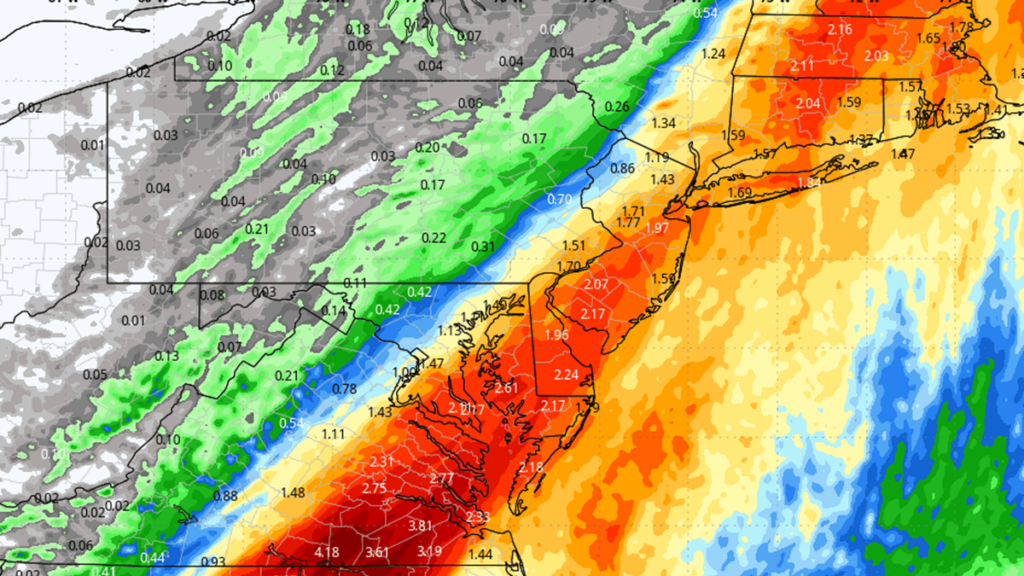
The low will bring periods of moderate-to-heavy rain between tonight (Wednesday) and tomorrow night (Thursday). Here’s what the high-res NAM is spitting out for total rainfall in inches ending late Thursday night:
No other significant concerns with this one (wind or coastal flooding). Just some flash flooding to watch out for (better probability) and possibly some embedded thunderstorm action (lower probability). The system then clears out with temps dropping Thursday night into Friday morning. A very transient colder period sets up for all of Friday into about Saturday morning. Then temps moderate for a drier and milder weekend.
In English: Rain is approaching and should gradually fill in from W to E this evening into overnight hours. Rain should then fall, moderate-to-heavy at times, through late Thursday PM. Conditions then clear and turn colder for Friday into Saturday morning. The rest of Saturday and Sunday look nicer which I’ll cover more in the weekend outlook tomorrow. For now, get ready for another soaker tonight through tomorrow night. Be safe! JC
Premium Services
KABOOM Club offers inside info forecast discussion, your questions answered, and early storm impact maps (ahead of the public). At a buck per month, it’s an extremely feasible way to show support.
My Pocket Meteorologist (MPM), in partnership with EPAWA Weather Consulting, offers professional/commercial interests, whose businesses depend on outdoor weather conditions (snow plowing, landscaping, construction, etc.), with hyper-local text message alerts/forecasts and access to the MPM premium forum—the most comprehensive and technical forecast discussion available for PA and NJ.
Jonathan Carr (JC) is the founder and sole operator of Weather NJ, New Jersey’s largest independent weather reporting agency. Since 2010, Jonathan has provided weather safety discussion and forecasting services for New Jersey and surrounding areas through the web and social media. Originally branded as Severe NJ Weather (before 2014), Weather NJ is proud to bring you accurate and responsible forecast discussion ahead of high-stakes weather scenarios that impact this great garden state of ours. All Weather. All New Jersey.™ Be safe! JC
