Another Snow Pattern Detected

Discussion: Winter is far from over. We’re on day 23 of a 90-day season with a long way to go. I see quite a few people cancelling the rest of winter, just because the first 1/4 to 1/3 of winter hasn’t worked out for them snow-wise. This would be a mistake. This is the top of the third inning of a 9-inning baseball game. It would be silly to leave the stadium at this point, especially since some NJ areas have a few runs already.
To recap, a favorable pattern for snowstorm development moved over NJ on Jan 2 and has now relaxed as of the last light snow event which occurred this past Saturday morning (Jan 11). As we saw, these patterns can occur without snowstorms coming to fruition, especially for everyone. A favorable pattern just means less working against snow from happening. It doesn’t guarantee a snowstorm for your specific area. A snowstorm pattern can be wasted as this last one was for much of NJ. So far this snow season, extreme NNJ saw a 12+ event that spanned across Scranton PA into NWNJ towards the end of November. NNJ/CNJ saw a light event prior to Christmas. Atlantic City and latitudes S of AC are sitting at or just above their annual average for this point in the season. For other areas, trust me…I get it. But it’s far too soon to give up on the remaining 65+ days of the season.
Jan 11 kicked off a dry period which should last until this Friday, Jan 17. Today (Monday) was the last day of a transient warmup. Tomorrow (Tuesday) begins a colder period into Friday morning. But today through Friday morning should be dry…each day casually colder then the previous day. Temps should then warm again for Friday-Sunday with rain moving in between Friday night and Saturday morning lasting into Sunday morning. Doesn’t look like hefty rain amounts either, more like passing showers here and there. But the completion of this weekend’s rain should end with a cold front and knock temps down for Monday-forward.
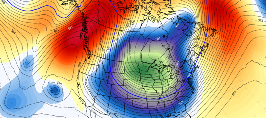
With a more prolonged cold establishing by Monday, Jan 20, we then have to look at a few things to verify the favorable snow pattern. First is a quick check of the El Nino Southern Oscillation (ENSO) cycle which remains in a near-neutral negative state (not a snowstorm killer). The Madden-Julian Oscillation will be progressing through colder phases through at least the end of next week before returning to a zone that is inconclusive (the circle of death). Looking more at the ensembles of the GFS and Euro, a cold and wet pattern is suggested for Jan 20-forward. These same ensembles predicted the current cold and dry pattern this week with great accuracy. Ensembles are cold well into February with of course, transient warmups (3 days or less) here and there. The negative phase of the Eastern Pacific Oscillation (EPO) looks to hold for the rest of January (outside of a transient warmer ~Jan 24-25 period) which tells me that W US ridging will be slowing the warmer Pacific Jet down and ramping it up into the W side of Canada. This has a downstream effect of letting cold Arctic air spill into the C US and E US. What I don’t see is a negative phase of the North Atlantic Oscillation (NAO) which is the blocking required for a historic snowstorm. But a persistent -EPO can at least get us to a significant, possibly major snowstorm. All-in-all, it’s another pattern favorable for snowstorm development starting Jan 20 and lasting at least towards the end of January.
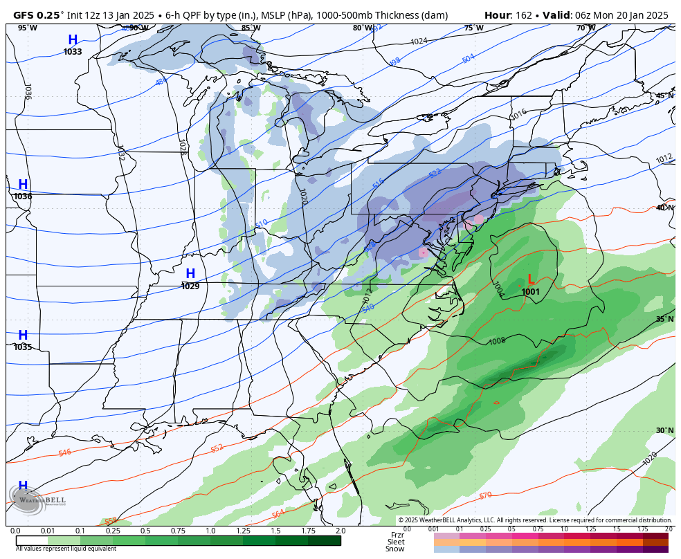
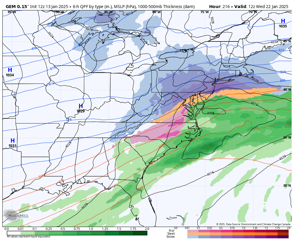
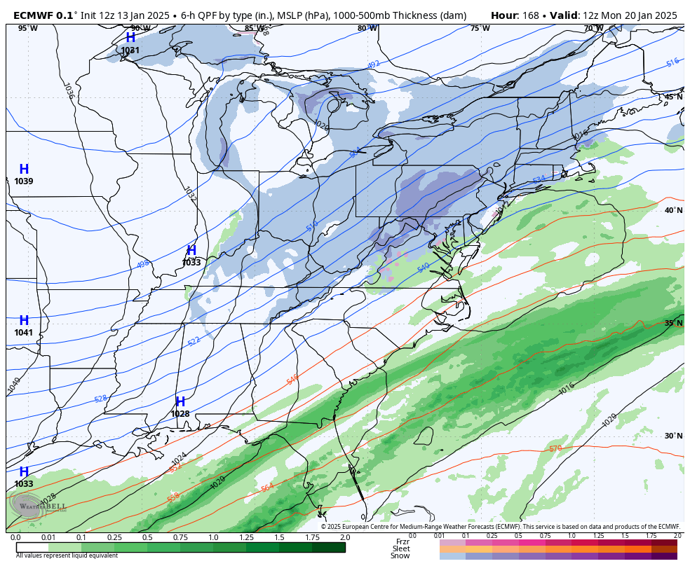
Now let’s discuss some storm signals showing on both the GFS and Euro ensembles. We’re going to have that ridging in W US and a trough over the E US. What’s jumping out at me is a train of synoptic signals. The models are all over the place on timing (which days will host a snowstorm). But I am seeing at least 3-5 synoptic systems riding that ridge and meeting up with the S stream between Jan 20 and Jan 28. Last we discussed; I believe I told you the next signal is Jan 19-21. Today I am looking at two in the somewhat near-future, Jan 20-21 and Jan 23-ish. The remaining 1-3 signals after that are too early to assign specific time periods to as they are jumping around way more than the first two. Heck these first two signals are still 6-7 and 9-10 days away. So let’s first focus on the potential for Jan 20-21. The earlier rain this weekend (Jan 17-19) ultimately wants to drag a cold front down over NJ upon its exit. The Jan 20-21 signal would then be in the form of a secondary wave just behind the rain system that rides the frontal boundary pulled S after the rain. The result would be a colder snowfall for NJ. There is agreement on this between the GFS, Euro, and Canadian models. This system could hold up the hard surge of Arctic air until after its exit, which is what you want to see if you want snow. Too much N cold force = suppression. Just enough cold would be ripped down behind the Friday-Saturday rain (Jan 17-19) to allow snow Monday-Tuesday (Jan 20-21). That’s what I’m looking at now as suggested by the GFS (top), Canadian (middle), and Euro (bottom). The GFS and Canadian are more enthused than Euro – but agreement on the signal is all I am looking for from this range:


An Arctic cold air mass would then ensue behind the Jan 20-21 signal leading up to the Jan 23 signal (more to come once we get handle on Jan 20-21). I expect I will have a lot more for you on the Jan 20-21 expectation by this Wednesday when we’re 5 days away from it. Until then, I am casually monitoring the signals for increased confidence in timing and surface expectations. I’ll let you know if the models are supported by the pattern and what it would mean for NJ. But there will not be a forecast until snow map time later this weekend. We are still in casually watching mode and have not moved into serious storm tracking mode yet. That will be this Wednesday if the Monday signal is still showing with confidence.
In English: We are dry from now until Friday. Today is the last day of a short warmup (highs in the 30s/40s). Tomorrow (Tuesday we’re back to highs in the 30s/lows in the teens/20s). On Friday we’ll start warming back up for a few days (Friday-Sunday) with some rain at times. When the rain ends (by Sunday), a cold front will take all NJ areas cold enough to snow by Monday morning. The first of many snowstorm signals still exists for the Jan 20-21 period (next Monday-Tuesday). The above model images illustrate surface precipitation output (blue is snow/green is rain/etc.) to get the general idea. Temps are then expected to dive further into Arctic territory again for next Tuesday-forward as other snowstorm signals present. A reminder that a snowstorm pattern doesn’t guarantee a snowstorm. This last pattern was wasted for many and that could very well happen again. I’ll be tracking and will update accordingly. Be safe! JC
Premium Services
KABOOM Club offers ad-free content, inside info forecast discussion, your questions answered, and early storm impact maps and video releases (ahead of the public). At two bucks per month, it’s an extremely feasible way to show additional support for Weather NJ. Think of it as a tip jar with perks. Available onFacebook or Patreon.
My Pocket Meteorologist (MPM), in partnership with EPAWA Weather Consulting, offers professional/commercial interests, whose businesses depend on outdoor weather conditions (snow plowing, landscaping, construction, etc.), with hyper-local text message alerts/forecasts and access to the MPM premium forum—the most comprehensive and technical forecast discussion available for PA and NJ.
Jonathan Carr (JC) is the founder and sole operator of Weather NJ, New Jersey’s largest independent weather reporting agency. Since 2010, Jonathan has provided weather safety discussion and forecasting services for New Jersey and surrounding areas through the web and social media. Originally branded as Severe NJ Weather (before 2014), Weather NJ is proud to bring you accurate and responsible forecast discussion ahead of high-stakes weather scenarios that impact this great garden state of ours. All Weather. All New Jersey.™ Be safe! JC


