

Active Pattern Continues
Discussion: We’re in the middle of a six, potentially seven, system onslaught. Three of them have passed, the two snow-to-ice-to-rain systems last week and last night’s CNJ/SNJ event. The next two (system #4 and #5) are also wintry-to-non-wintry systems and the last two I’m tracking are still too far away for details, but still a strong synoptic signal next Wednesday-Friday (Feb 19-21). A hazy seventh is showing up around Feb 24 but we’re at least 5 days from even looking at it. These next three all happen in the immediate 7-day forecasting period. We’ll start out with a storm recap for last night and then address the three systems individually.
Storm Recap: Last night/overnight this morning went about as expected. Using our final call snow map zones for reference, Zones A and B saw their light snow in the form of just flurries to dustings here and there. No one exceeded 2 inches N of I-78. Zone C verified on the lower end of ranges for N sections and higher end of range for S sections…with some S areas of C booming just above the 4 inch mark. Most of Zone D saw a 4-6 outcome as expected with some areas slightly exceeding 6 inches in the SE Atlantic County area (Villias). Zone E saw many 6+ reports with 7-8, about the highest I saw from reports. This was a thread-the-needle weak wave that took advantage of a cold airmass ready to depart (departing today). All-in-all, we are very happy with our forecast as it achieved near total verification. Onto the next one…
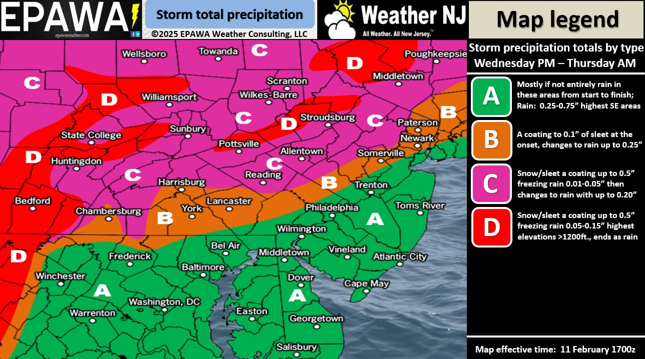
Today/Tonight (Feb 12): The most noticeable theme of today is that areas hardest hit last night are the warmest now. The surface line of freezing is up near I-80 in NNJ. Meanwhile, some ocean effect precipitation is coming off the ocean into Monmouth and Ocean Counties. It might fall in the form of snow because it’s still colder aloft but is quickly melting on contact or changing to rain just before hitting the surface. Not a big deal. A little bit later today, more precipitation will push in from the W. Precipitation could be mixed in the form of snow and sleet for NNJ N of I-78 and NW of I-287. We think about a half-inch of total snow + sleet accumulation is possible for said areas before warmth overtakes the surface and aloft, sending even those areas to rain. I doubt anyone will exceed an inch. Whether a half-inch or an inch, is a negligible outcome and will be washed away by rain eventually. The rest of NJ should expect to start, stay, and end with all plain rain. So the wintry potential is for N of I-78/NW of I-287 between about 4pm and midnight tonight…not heavy and in a marginal temp situation. By midnight, even NNJ should change to sleet then rain like the rest of NJ. This rainfall is much needed. Here is an impact map for tonight into tomorrow morning:
Saturday-Sunday (Feb 15-16): This weekend we’re dealing with another snow-to-ice-to-rain situation but this one should start a colder than tonight’s system. Despite being under a ridge, NJ will turn colder Thursday night into Saturday’s approaching system #2. The GFS is colder than the Euro. The GFS has almost statewide snowfall Saturday evening before changing to all rain statewide by Sunday morning. The Euro only brings starting snow into NNJ only before changing to all rain statewide by Sunday morning. All models then rain pretty good into Sunday night. More much needed rainfall. As far as how many inches of snow could fall Saturday night before the changeover, that’s yet TBD and will be a focal point for the next few days. We need the solution to come together more. Right now, the Euro drops C-2”/1-3” across NNJ only and the GFS drops 3-6” NNJ, 1-3” CNJ, and trace/C-1” for SNJ.
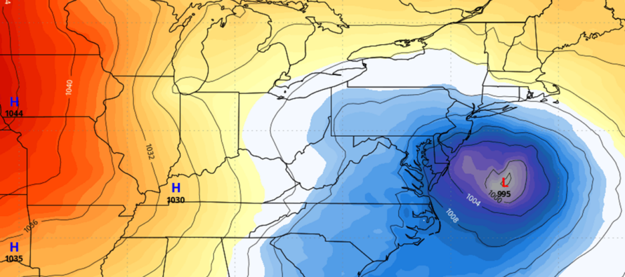
Wednesday-Friday (Feb 19-21): This is the one I’m more excited about from a snow lover’s POV (pictured above on the GFS). First, the reason for the warmer systems today through Sunday will be a temporary retreat of the negative phase of the Eastern Pacific Oscillation (EPO). This will allow the warmer SE Atlantic Ridge to push into/over NJ from the SE. More importantly, the ridge will push the storm highway/track well NW of NJ. These next two systems through this weekend, that are snow-to-ice-to-rain for NJ, will likely be solid snowstorms for northern New England. Then behind the Sunday night ending-rain, temperatures will crash fairly hard. The EPO will return to a negative state and the SE Atlantic ridge will back away to the SE away/off of NJ. The air behind the Sunday PM/Monday AM cold front will be of Arctic source, transported from the N Pole via cross-polar flow. I would then expect a colder Monday-Wednesday of next week. Monday-Tuesday the most shocking cold with some moderation by Wednesday but still cold. And that brings us to a storm signal window where a trough will swing and interact with a coastal low. There’s not much more to say at this point. An early capture could bring temperature issues to the signal. A late capture could mean a miss out to sea. A favorable-timed capture would mean a massive snowstorm for New Jersey. A slightly off-capture could mean a smaller snowstorm for New Jersey. All options are on the table for New Jersey but it does look like there will be a capture system in that Feb 19-21 (Wed-Fri) period for the east coast. And it’s backed with he supportive horsepower of a weak La Nina, -EPO, and favorable phase of the Madden Julian Oscillation (MJO). We are 7 days away from this system and I will report accordingly. If something looks promising by the end of this weekend, we’ll start serious tracking.
There’s another signal Feb 24 but at 12 days away, it’s well beyond the 7-day window of realistic forecasting for surface conditions. Will keep this very casual on the backburner. It does not look like an early spring however. The groundhog might have been right. Still a few innings of baseball to play but you can’t deny the runs scored by NNJ this past Saturday and SNJ last night. Here’s to hoping for the CNJ snow lover to fill in the gap.
In English: NNJ could see a little wintry mix this evening before changing to all rain like the rest of NJ by midnight tonight. Rain should end by Thursday afternoon/early evening. We’re then dry (windy into the weekend) until about Saturday when snow/rain should push into NJ in another snow-to-rain situation. A small chance of light-to-significant snow accumulations Saturday night before all of NJ goes to rain again by early Sunday morning ending Sunday night. A cold front then crashes temperatures for the Monday-Wednesday period of next week (dry). Wednesday-Friday (Feb 19-21) is the next synoptic signal I am following for NJ snow with a weak signal a few days after that around Feb 24. That should complete the train of 6-7 systems that began Wednesday Feb 5 with the -EPO pattern. I’ll check in later tonight with some radar observations. We’re going to stay in storm mode ahead of the Saturday snow potential and then for next Wed-Fri. Have a great rest of your Wednesday and please be safe! JC
Premium Services
KABOOM Club offers ad-free content, inside info forecast discussion, your questions answered, and early storm impact maps and video releases (ahead of the public). At two bucks per month, it’s an extremely feasible way to show additional support for Weather NJ. Think of it as a tip jar with perks. Available onFacebook or Patreon.
My Pocket Meteorologist (MPM), in partnership with EPAWA Weather Consulting, offers professional/commercial interests, whose businesses depend on outdoor weather conditions (snow plowing, landscaping, construction, etc.), with hyper-local text message alerts/forecasts and access to the MPM premium forum—the most comprehensive and technical forecast discussion available for PA and NJ.
Jonathan Carr (JC) is the founder and sole operator of Weather NJ, New Jersey’s largest independent weather reporting agency. Since 2010, Jonathan has provided weather safety discussion and forecasting services for New Jersey and surrounding areas through the web and social media. Originally branded as Severe NJ Weather (before 2014), Weather NJ is proud to bring you accurate and responsible forecast discussion ahead of high-stakes weather scenarios that impact this great garden state of ours. All Weather. All New Jersey.™ Be safe! JC


LOCAL FORECAST | INTERACTIVE RADAR | LATEST NJ WEATHER ALERTS | WEDDING FORECAST| PRIVACY POLICY
© Copyright 2025 Weather NJ LLC. All Rights Reserved.
Some information that can be found on our website is provided by a private weather station and is not an officially recognized station for weather reporting. Though we always strive to achieve accurate reporting for our own use, it is important that you do NOT depend on the data provided here for any purpose.
