

A Deep Dive Update for Wed-Thurs Snowstorm
Discussion: Today’s article is going to be a deep dive into what’s going on with the Wednesday-Thursday snowstorm signal. So that I don’t waste anyone’s time, this article will not be conclusive, nor will it offer an official forecast. That’s coming tomorrow at the earliest. At most today, I will offer a chicken-scratch drawing over a blank radar image to illustrate my thoughts which I at least owe you…if I had to make a map today. You can skip right to the In English part to see that drawing (right above the In English part) which will probably address most interests today. But our official map where we put our total evidence collection into a predicted outcome will not be until snow map time. Now for those who want to geek out with me on some meteorology, read on.
First, let’s get some hard raw facts out of the way. We’re dealing with a phase capture of two different streams of energy. This is risky business. This is why we refuse to issue forecasts until closer to the event…why we remain in just “serious signal tracking mode.” I told snow lovers that this one would alternate between euphoric fantasy and heartbreak. Well the model runs between yesterday afternoon and today have been heartbreaking for the snow lover after providing a euphoric fantasy the prior days before. Why has this happened? Mainly because of the timing of the two pieces of energy. Let’s look at some 500mb geopotential heights and cyclonic relative vorticity, along with some of my quality chicken scratch:
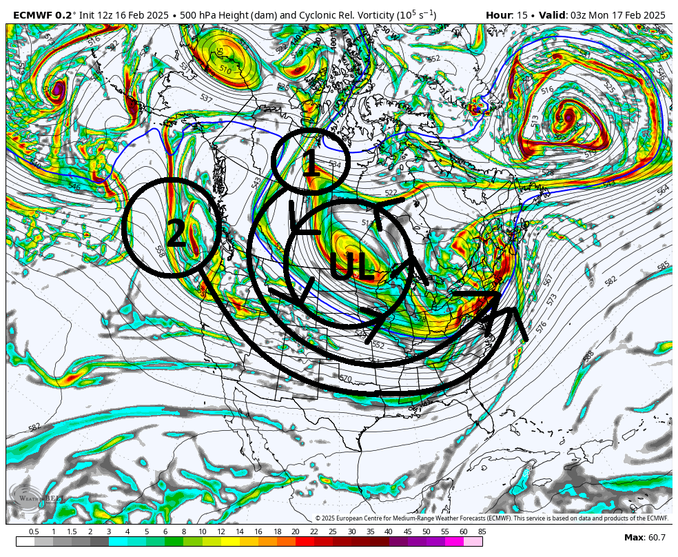
The marked Upper Low (UL) controls most of the current US pattern with a general cyclonic (counter-clockwise) rotation as all cyclones in the Northern Hemisphere spin. Our two pieces of energy are marked as 1 (the northern stream) and 2 (the southern stream). 1 is over Canadian land and much better sampled. 2 is still over the E Pacific and will over land by late tonight (Sunday night) or early tomorrow (Monday) morning. At that point both streams will be fully sampled over land where there are a lot more weather sensors to feed current conditions into the weather model inputs. When this happens, you typically see corrections in model output. That’s why we can’t even think about a forecast until Monday afternoon at the earliest. However, the principals remain. The UL will steer both pieces of energy (1 and 2) around its southern side until eventually they merge into a single piece of larger and more powerful energy. This is called a phase. The phase then captures the southern surface low, that will be ejecting off the SE US, holds it in place for a little before pulling away further in the Atlantic Ocean.
If these two pieces of energy were to meet earlier than expected, then we’d have a low close to the coast bringing ice/rain into SENJ with a snowstorm NW of I-95. If the pieces meet too late, then we’d see a total miss to the S and E out to sea. If they meet at the perfect time, then all of NJ sees a 12+ inch KABOOM snowstorm. So where are we today? The pieces of energy are meeting just a few hours late which is producing a SENJ snowstorm with everyone else in NJ feeling weighed; measured; and found wanting. To further explain how the pieces of vorticity influence the steering currents, let’s look at a 500mb heights map only:
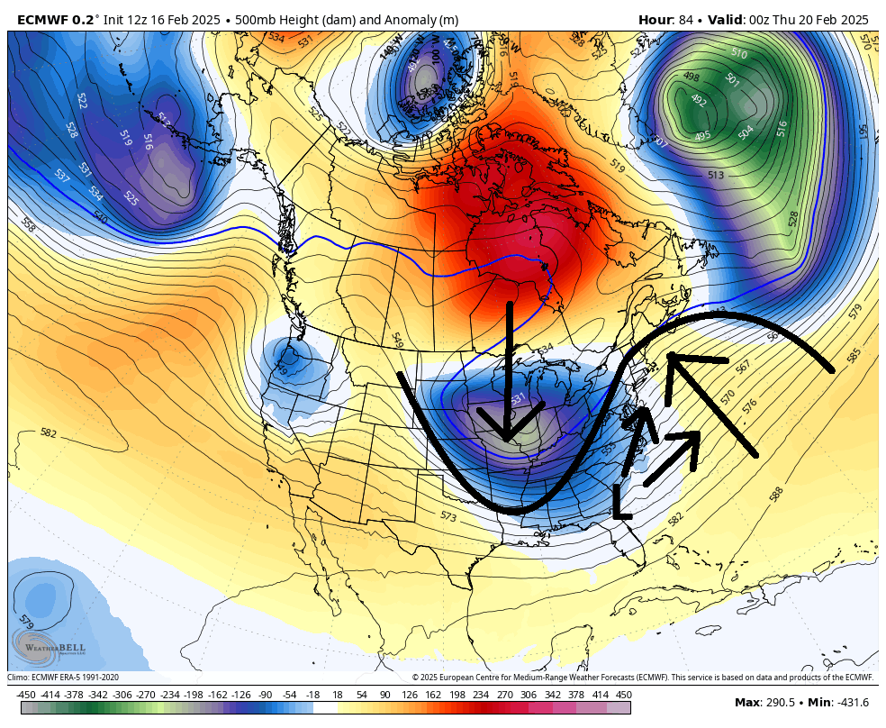
The earlier the two pieces meet, the further they will deepen the trough seen in the central-eastern US. The ridge, just downstream over the W Atlantic Ocean, then responds to the trough deepening by building into the Maine/Nova Scotia regions. If the trough is too deep (pieces phase too early) then it would turn the surface low off the SE US too far northward and NJ would see the warmer scenario. If the trough is too shallow (pieces phase too late), then the surface low ejects out to sea and NJ misses. This is why we need the pieces of energy to come together at the right time, so that the trough/ridge relationship creates the perfect steering currents for the surface low off the SE US. And the steering currents are right there for you to see on image two…they act as rails for the surface low.
So again, the two pieces of energy, over the last 24 hours of model guidance, have been modeled to meet about 3-5 hours later where we need them to meet for the statewide KABOOM. However, they are meeting in time to hit SENJ with significant-to-major snowfall, possibly a KABOOM SE of I-95. If you want to see this come back into more of a statewide major snowfall, we need the southern stream (system #2) to slow down which would allow for a faster phase and capture of the surface low. That is what I will be paying specific attention to over the next 24-48 hours as we hone into a consensus. We’re still over 72 hours from first flakes and we’re looking at 84-96 hours before it’s all said and done. There are time and room for changes.
A final note about temperatures and pattern. Snow ratios are going to be very high due to snowfall occurring in mostly an 18-24F environment. We’re talking about 15 to 20:1 ratios. Very powdery stuff that stacks very easy. 1-2 inch+ per hour stuff under the heavier meso bands. This should not be wet Wed-Thurs. As far as the pattern goes this winter, storm systems have been favoring SNJ. Atlantic City and Cape May are above average snowfall for the year where the rest of NJ (NNJ/CNJ) are below. Some might call it atmospheric memory. Most just call it a seasonal pattern. But there is something to be said when multiple events over a few months behave similarly.
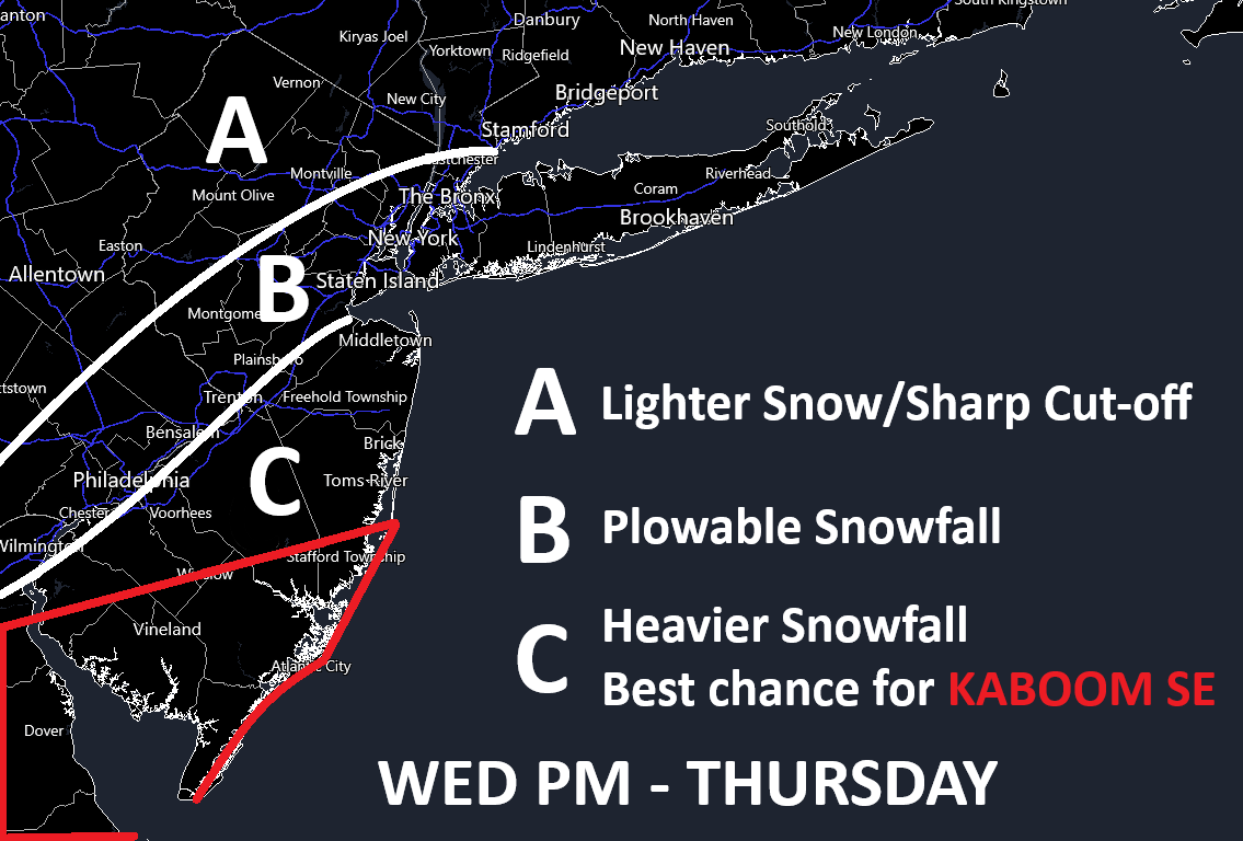
As promised, here is some more chicken scratch representing my thoughts if I had to make a map today. No amounts or additional timing details outside the Wed PM-Thurs window. All coming in due time. Just general ideas for now. This is a little NW of current model guidance however it represents where I think it will come back to (about). The cover is from the most recent NAM run indicating more of a NW track idea….would have brought more snow to NJ than my map below. Fun times ahead. Note: All of zone C could KABOOM, but the red area has the best chance.
In English: Freezing rain overperformed with respect to the forecast for NNJ areas where cold was slower to retreat. The Mt. Pocono into NWNJ elevations area specifically. All areas are now raining though. One rain squall is through today. Another is back near Harrisburg, PA heading towards NJ. This final squall could nest some embedded thunderstorms as it has done so further W along the Mason Dixon line. It should be through by sundown and then temps will drop and winds will switch from S to NW and pick up even more than they already are. Winds should help dry most of the ground moisture before the freezing temps move in but possibly not all of it. Please use extra caution tonight and tomorrow on any surfaces still looking wet. If they look wet, assume it’s frozen. Otherwise salt and wind-assisted evaporation should suffice most roadways. Much colder conditions then persist to start this week and last right through the snowstorm period Wed-Thurs. I go into a pretty deep dive on Wednesday-Thursday above. In a nutshell models have trended from a statewide major snowstorm to more of a SENJ snowstorm with lighter amounts the further you get away from SENJ. See above rough idea map of where I’m at today. I expect some model correction overnight, but the SE trend seems to have hit its max point. Model guidance tonight and tomorrow morning will be critical for moving forward with a more detailed forecast tomorrow. Have patience, don’t live and die by the “weather apps”, and let’s see where we stand tomorrow. Have a great rest of your Sunday night and please be safe! JC
Premium Services
KABOOM Club offers ad-free content, inside info forecast discussion, your questions answered, and early storm impact maps and video releases (ahead of the public). At $1.99 per month, it’s an extremely feasible way to show additional support for Weather NJ and you can can turn it on and off for however many months you wish. Think of it as a tip jar with perks. The public eventually sees all info discussed in premium areas. Available onFacebook or Patreon.
My Pocket Meteorologist (MPM), in partnership with EPAWA Weather Consulting, offers professional/commercial interests, whose businesses depend on outdoor weather conditions (snow plowing, landscaping, construction, etc.), with hyper-local text message alerts/forecasts and access to the MPM premium forum—the most comprehensive and technical forecast discussion available for PA and NJ.
Jonathan Carr (JC) is the founder and sole operator of Weather NJ, New Jersey’s largest independent weather reporting agency. Since 2010, Jonathan has provided weather safety discussion and forecasting services for New Jersey and surrounding areas through the web and social media. Originally branded as Severe NJ Weather (before 2014), Weather NJ is proud to bring you accurate and responsible forecast discussion ahead of high-stakes weather scenarios that impact this great garden state of ours. All Weather. All New Jersey.™ Be safe! JC


LOCAL FORECAST | INTERACTIVE RADAR | LATEST NJ WEATHER ALERTS | WEDDING FORECAST| PRIVACY POLICY
© Copyright 2025 Weather NJ LLC. All Rights Reserved.
Some information that can be found on our website is provided by a private weather station and is not an officially recognized station for weather reporting. Though we always strive to achieve accurate reporting for our own use, it is important that you do NOT depend on the data provided here for any purpose.
