It appears that the mini-warmup this week will be a transient occurrence. Temperatures will peak on Wednesday and precede a stormy evening-overnight. Once the cold front moves through on Thursday, temperatures will return to below-average. We’re talking about afternoon highs in the lower-80s and overnight lows ~60. I’m expecting at least a few pleasant days with cool and comfy nights Thursday through at least Sunday.
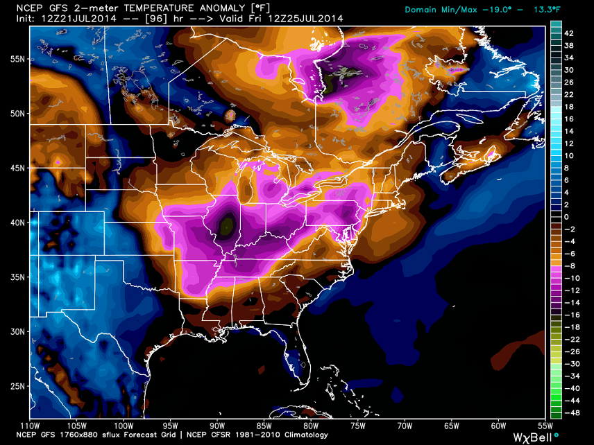
Why is this happening? High pressure keeps diving south into the eastern 2/3 of the US from Canada forming massive troughs that affect our region. This is very similar to what happened this past winter. Here’s a good snapshot of what to expect Friday morning per the latest GFS:
As you can see, temperatures are expected to be 6-14 degrees below average. Don’t run for your winter gear just yet it’s still July. We’re talking about warm spring conditions in mid-summer. It’s bizarre because the opposite is happening for the western 1/3 of the US. They are experiencing massive hot and dry ridges which are resulting in drought. If you look at global temperature anomalies (departures from average), the rest of the planet is warmer than the eastern 2/3 of US. It’s a strange pattern but again, it has yet to break since this past winter.
I’ll be revisiting the stormy setup for Wednesday-Thursday later tonight. Be safe! JC
Model images courtesy of WeatherBell Analytics.
Jonathan Carr (JC) is the founder and sole operator of Weather NJ, New Jersey’s largest independent weather reporting agency. Since 2010, Jonathan has provided weather safety discussion and forecasting services for New Jersey and surrounding areas through the web and social media. Originally branded as Severe NJ Weather (before 2014), Weather NJ is proud to bring you accurate and responsible forecast discussion ahead of high-stakes weather scenarios that impact this great garden state of ours. All Weather. All New Jersey.™ Be safe! JC
