

Snowstorm Detected for Tues-Wed
Discussion: If the 18Z model guidance remains consistent through this evening for Tuesday-Wednesday, we will transition to storm mode during the Super Bowl. That means serious tracking for a legitimate snowstorm has begun and there will be zero tolerance for bots, trolls, and negative lashing out. Not even going to bother responding, as many of my “normal, courteous and reasonable” followers have suggested. Just going to delete and ban. This also means that answering questions will be next to impossible outside of the premium subscription area where I’ve been providing run-to-run model analysis and actually discuss building the snow maps. But before we dive into Tuesday-Wednesday, let’s recap
Last night’s event fell short snow-wise but performed exactly as forecasted otherwise with the more important dangerous ice features (sleet and freezing rain). I understand that to some, snow is the only thing cared about. But with overrunning warm air advection events (like system #1 Wed-Thurs and system #2 last night), snow is a lesser concern safety-wise. In the 30 or so of these type events that I’ve forecasted since about 2010, about 20-25 of them featured underperforming snow than what the model guidance suggested even in the 11th hour. In most cases, whatever snow does fall gets compacted by sleet or melts away quickly when temps eventually rise above freezing. It seems like no matter how much I stress a snow-to-ice-to-rain situation, the public only focuses on snow lol. And some seem to think it all falls at once…if I put a live observation out a few minutes after first flakes, people be like “I got nothing BUST!” I’m not sure I understand why this happens but you have to let the storm play out before drawing conclusions on forecast performance. Last night there was an ice event, and it was ice that presented the most dangerous safety travel hazards in the form of sleet and freezing rain accrual, not the few inches of up-front snow. It’s why I used Vanilla Ice lyrics ahead of the two events. It’s why I didn’t present the system as a snowstorm only. My main theme for the past two weeks has been to get through the two snow-to-ice-to-rain events so that we can step into the more favorable Feb 10-15 period for snow development.
As far as an explanation for why you saw 3-4 inches of snow in NNJ if you were expecting 4-6….as to why you saw 1-2 inches in lower NNJ/CNJ if you were expecting 2-4…as to why you saw a coating of sleet for other parts of CNJ/SNJ instead of C-1/2 inches of snow + sleet… there was some dry air intrusion both at the initial start of the precipitation (the late fill-in) and towards the end of the system (the deteriorating precipitation shield later at night/overnight). This was primarily caused by the primary low, that came in from Ohio, establishing dominance over the coastal low developing of OBX, which raced the warm air advection in despite the late precipitation. Again, I wasn’t really concerned with upfront snow. The ice that followed was much more dangerous. The good news is that the warmer solution created by the primary low’s dominance should now allow a further north solution for Tuesday-Wednesday. So… enough about the two slop events (system #1 and #2). It’s now time for the system #3 I’ve been waiting for since about Jan 29…a mostly/all-snow snowstorm.
This next system is slightly less challenging to forecast as the biggest unknowns are the northern extent of light snow/cut-off and the location of the jackpot axis through CNJ/SNJ. No sleet, freezing rain, or rain to deal with unless it trends far enough N to bring extreme SNJ into a temporary mix. Today (Sunday) and tomorrow (Monday) should be milder days above freezing for most NJ areas…highs in the 30s/40s. On Tuesday, parts of SNJ should rise just above freezing to about the 34-36 range while NNJ and most of CNJ stay at or just below freezing. The snow is then expected to push in sometime between afternoon and evening as temps drop into sunset/overnight colder hours. There is still some discrepancy in timing as to the start and end times but the peak snowfall is looking to occur between sunset Tuesday evening and Sunrise Wednesday morning with lighter snow in front (leading up) and back (tapering off) of the peak period.
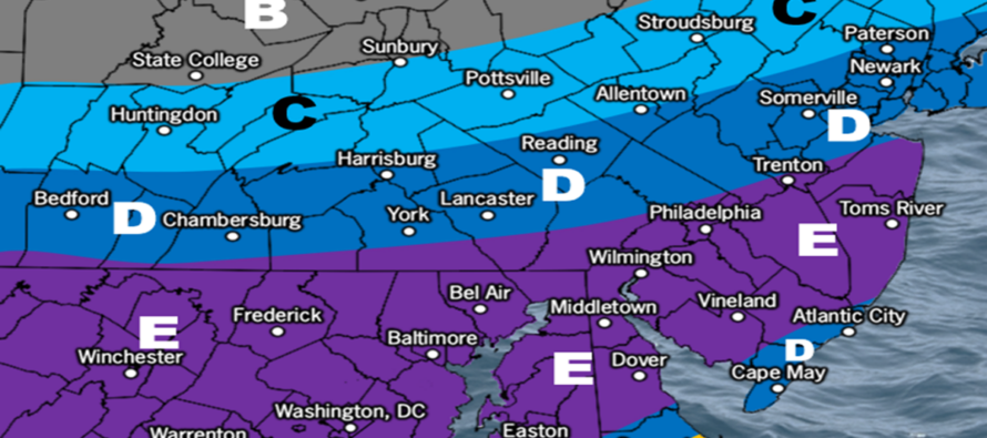
We’re looking at a very weak surface low tracking W to E across the gradient thermal boundary and ejecting/deepening slightly off OBX before tracking E/SE in the Atlantic. We’ll have a very strong gradient of cold air to the N of the gradient (over NJ) and warm moist air to the S of the gradient (lower Delmarva/DC latitude and S). Here is our initial wintry ideas map.
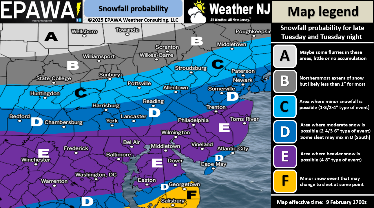
In English: The two icy systems are finally through, and we can now anticipate more a traditional snowstorm currently targeting CNJ and SNJ with the highest amounts. It is still uncertain as to how much NNJ sees due to said area being on the northern fringe/cut-off of the precipitation. See the above ideas map for what your area can generally expect. Tomorrow there will be a much more detailed map with specific expected amounts by zone. This snowstorm should start between Tuesday afternoon and evening, peak overnight into Wednesday AM and then end between Wednesday morning and afternoon. That’s the general timing expectation for now which will also be consolidated with tomorrow’s update. Have a great rest of your Sunday and please be safe! JC
Premium Services
KABOOM Club offers ad-free content, inside info forecast discussion, your questions answered, and early storm impact maps and video releases (ahead of the public). At two bucks per month, it’s an extremely feasible way to show additional support for Weather NJ. Think of it as a tip jar with perks. Available onFacebook or Patreon.
My Pocket Meteorologist (MPM), in partnership with EPAWA Weather Consulting, offers professional/commercial interests, whose businesses depend on outdoor weather conditions (snow plowing, landscaping, construction, etc.), with hyper-local text message alerts/forecasts and access to the MPM premium forum—the most comprehensive and technical forecast discussion available for PA and NJ.
Jonathan Carr (JC) is the founder and sole operator of Weather NJ, New Jersey’s largest independent weather reporting agency. Since 2010, Jonathan has provided weather safety discussion and forecasting services for New Jersey and surrounding areas through the web and social media. Originally branded as Severe NJ Weather (before 2014), Weather NJ is proud to bring you accurate and responsible forecast discussion ahead of high-stakes weather scenarios that impact this great garden state of ours. All Weather. All New Jersey.™ Be safe! JC


LOCAL FORECAST | INTERACTIVE RADAR | LATEST NJ WEATHER ALERTS | WEDDING FORECAST| PRIVACY POLICY
© Copyright 2025 Weather NJ LLC. All Rights Reserved.
Some information that can be found on our website is provided by a private weather station and is not an officially recognized station for weather reporting. Though we always strive to achieve accurate reporting for our own use, it is important that you do NOT depend on the data provided here for any purpose.
