

More Wintry Storms Detected
Discussion: Our first of the three storm signals has passed through, Parts of NNJ saw a coating to an inch of snow+ sleet but sleet was the dominant form of wintry precipitation before most areas went to plain rain. It was an icy mess for NNJ and parts of CNJ early this morning but most areas improved drastically closer to sunrise. This first event was the weakest and warmest event of the series we are now into.
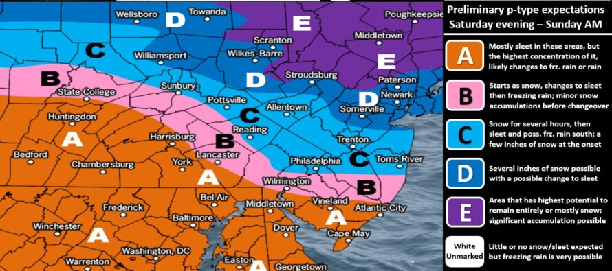
The next event (system #2) is expected between Saturday night and Sunday morning of this weekend. We expect a similar type event to storm #1 just a little colder. You’ll notice how most of NJ made it above freezing today…just above for NNJ and as high as lower-40s for SNJ. Tomorrow will also be milder but not as mild as the warmth prior to this past system. SNJ should hit 40-45 on Friday instead of 47-53 like a few days ago. That’s because the thermal gradient boundary is lower in latitude behind system #1 than it was ahead of system #1. Therefore, system #2 low will track along this boundary and be a little S of system #1 ultimately resulting in a slightly colder system this weekend. What does that mean? It means maybe the eventual above-32F rain line only makes it to I-195 instead of I-78/I-287. It means more snowfall on the front end for NNJ/CNJ before ultimately transitioning to poor dendritic growth/ice but not rain. It means a higher ice outcome for CNJ areas and a little less rain for CNJ/SNJ. We put together an expected precipitation type map but have not yet given totals. Totals will come tomorrow. But for now, this is our best interpretation of what to expect this Saturday night into at least the first half of Sunday:
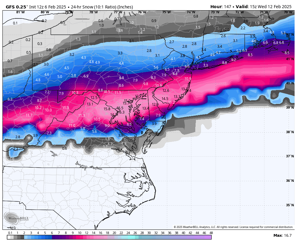
On Sunday we warm back up and stay on the milder side through Monday. Tuesday morning, some areas might be allowed to rise just above freezing before the next system (system #3) moves in which looks much colder than system #1 and #2. System #3 is currently targeting CNJ and SNJ with significant-to-major snowfall with NNJ on the lower-range N fringe seeing light-to-significant snowfall. I wouldn’t lock anything in at this range as I feel there is some play here in latitude. If this ends up a little N, then it could bring extreme SNJ into more of a snow/sleet situation while NNJ cashes in a little more on the jackpot. A little play S and then only SNJ would jackpot with CNJ seeing fringe snowfall and NNJ possibly getting left out. But for right now, this is the GFS output for System #3 only. Other models are supportive or either coming on board with a similar solution:
There’s another system later in the week but I’m only keeping an eye on it. Some guidance says it’s just one system on Thursday-Friday, others say one Thursday and then a 4th closer to Sunday. Since all of these systems are dependent on the thermal gradient boundary set behind each storm, it doesn’t make sense to focus on later next week. It makes sense to focus on the Tuesday snowstorm which is now inside of a 5-day window from starting. It looks like a rather wintry ride through about Feb 16th maybe even the 20th with the expected onslaught of wintry-type systems.
In English: After a milder Friday, another snow-to-ice-to-rain system is expected this Saturday night into Sunday. This one looks a little colder though. It will probably start either late Saturday night or just after midnight Sunday. See our wintry impact map above for an idea of what we expect. Tomorrow, our maps will include accumulation amounts. This map simply gives an idea on precipitation types for now. We then warm up Monday through Tuesday morning. Temps then drop later Tuesday morning ahead of a much colder snowstorm expected to impact most of Tuesday. Right now, it’s targeting all of NJ with a CNJ/SNJ jackpot. I expect this to windshield wiper a little N and S but by the end of this weekend, we’ll likely be dialing into snow maps and forecasts. Like I said, we’re only 5 days away. It might get a little hectic forecasting for Tuesday while experiencing Saturday night into Sunday but I won’t let you down. Tomorrow, we’ll likely go into storm mode for the upcoming week of multiple events. Tuesday cannot be called a KABOOM yet. But I do have it on standby should it appear imminent this weekend. Have a great rest of your Thursday and please be safe! JC
Premium Services
KABOOM Club offers ad-free content, inside info forecast discussion, your questions answered, and early storm impact maps and video releases (ahead of the public). At two bucks per month, it’s an extremely feasible way to show additional support for Weather NJ. Think of it as a tip jar with perks. Available onFacebook or Patreon.
My Pocket Meteorologist (MPM), in partnership with EPAWA Weather Consulting, offers professional/commercial interests, whose businesses depend on outdoor weather conditions (snow plowing, landscaping, construction, etc.), with hyper-local text message alerts/forecasts and access to the MPM premium forum—the most comprehensive and technical forecast discussion available for PA and NJ.
Jonathan Carr (JC) is the founder and sole operator of Weather NJ, New Jersey’s largest independent weather reporting agency. Since 2010, Jonathan has provided weather safety discussion and forecasting services for New Jersey and surrounding areas through the web and social media. Originally branded as Severe NJ Weather (before 2014), Weather NJ is proud to bring you accurate and responsible forecast discussion ahead of high-stakes weather scenarios that impact this great garden state of ours. All Weather. All New Jersey.™ Be safe! JC


LOCAL FORECAST | INTERACTIVE RADAR | LATEST NJ WEATHER ALERTS | WEDDING FORECAST| PRIVACY POLICY
© Copyright 2025 Weather NJ LLC. All Rights Reserved.
Some information that can be found on our website is provided by a private weather station and is not an officially recognized station for weather reporting. Though we always strive to achieve accurate reporting for our own use, it is important that you do NOT depend on the data provided here for any purpose.
