

Snow and Ice Storm Approaching
Discussion: There’s very little change in our forecast and maps issued yesterday for tonight (Wednesday night) into tomorrow (Thursday). So I am going to use this article opportunity to drill down on what to expect by NJ region.
First, here are the two most recent maps. The only changes for today are some consolidations of info in the legend really. First is the snow and sleet map, second is the freezing rain map:
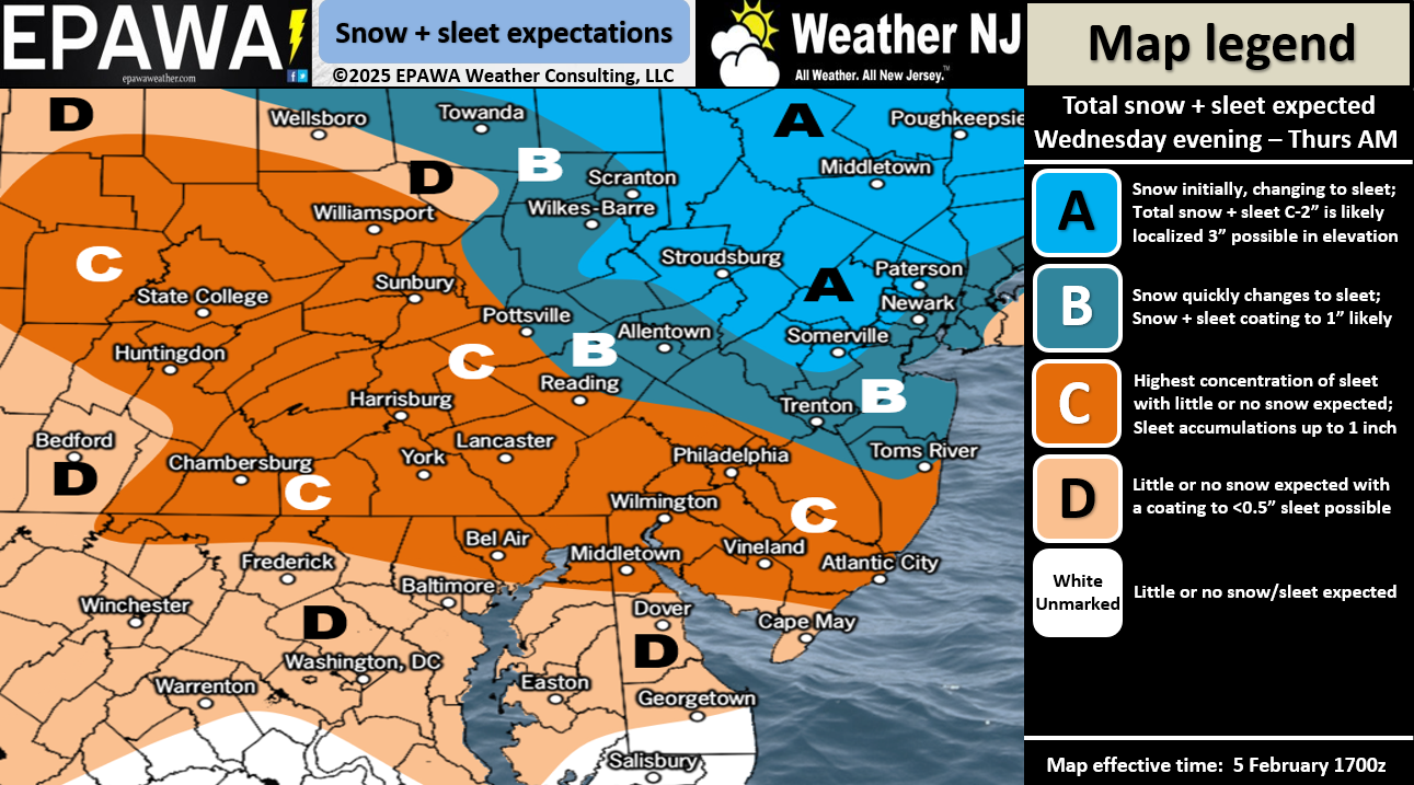
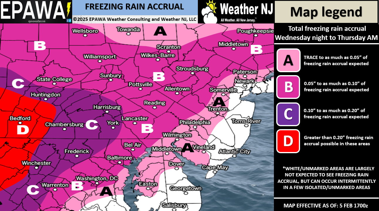
NNJ/NWNJ (N of I-78 and NW of I-287): This area should feature the snowiest upfront portion of precipitation. It includes Zone A on the snow and sleet map. This starts later this evening/early Tuesday AM and snows until around sunrise Thursday morning, maybe just before, before transitioning to sleet and then freezing rain. This area has the best chance to avoid rain all together and just end up being a snow-to-sleet-to-freezing rain solution with no ending plain rain. For this reason, we feel this area should see somewhere between a coating and 2inches of snow before the changeover. Possibly a little higher in higher elevations but we’ll see. This area also should see the most ice accrual from freezing rain once the snow and sleet changes over. This area is in Zone B and a little of A on the freezing rain map.
CNJ/NENJ (N of I-195 and S of I-78 and SE of I-287): This area should see the second most amount of snow (coating to an inch or two) before transitioning to a longer period of sleet/freezing rain and a shorter period of ending rain. The rain line is going to push into NJ from the SE. So SENJ almost immediately changes over to rain. We expect that rain line to eventually push into somewhere in Zone B of the snow and sleet map between mid-to-late morning Thursday. You can assume that areas like Monmouth County and N Ocean County will see more rain to end than the Trenton area, which should end with more freezing rain/less plain rain. NENJ should vary N to S (more wintry to less wintry). This area includes Zone A of the freezing rain map which suggests W parts of this area (near Trenton) see more freezing rain to end vs E parts of this area (near NYC and coastal areas) which should end with more of a plain rain
SNJ (All of NJ S of I-195): This area should only see a brief period of snow to start, with little-to-no accumulation, before changing over to sleet between midnight tonight and sunrise Thursday morning. The way things are looking, the W side of Zone C (closer to Philly) should transition to more of a freezing rain after sleet. The E side of Zone C should go almost straight from sleet to plain rain due to warmer marine influence. Extreme SENJ should see very little wintry precip before becoming all rain with a surface of 32F or higher.
Timing: I’m looking at this thing get its act together on radar over in the Ohio River Vally region and it’s coming. I expect the meat and potatoes of precipitation to start around midnight tonight but its possible that lighter precip could break out earlier than that. It should start in SWNJ and take a few hours to push into NNJ. I expect most precipitation to wrap up by noon tomorrow (Thursday).
In English: No big changes to our going wintry impact maps and forecast issued yesterday. A transitional weather system will push through NJ between late tonight (late Wednesday night) and about noon tomorrow (Thursday). Transitional meaning it starts out wintry and ends non-wintry (snow-to-sleet-to-freezing rain-to-plain rain). The further N and W in NJ you are, the more wintry you will see before becoming non-wintry. The further S and E you are in NJ, the less wintry you will see before becoming mostly non-wintry. The actual specific time of transition from each precipitation type to the next is impossible to nail down because it’s a complex mess. Our wintry impact maps above are our best shot of expectations. Live observations will start later tonight. The weekend event still looks similar to this event however has trended a little colder which would mean more upfront wintry than non-wintry. Then next week still looks like a bigger snow event or two. This weekend and next week will be covered in detail starting tomorrow once this system is out of here. Have a great rest of your Wednesday and please be safe! JC
Premium Services
KABOOM Club offers ad-free content, inside info forecast discussion, your questions answered, and early storm impact maps and video releases (ahead of the public). At two bucks per month, it’s an extremely feasible way to show additional support for Weather NJ. Think of it as a tip jar with perks. Available onFacebook or Patreon.
My Pocket Meteorologist (MPM), in partnership with EPAWA Weather Consulting, offers professional/commercial interests, whose businesses depend on outdoor weather conditions (snow plowing, landscaping, construction, etc.), with hyper-local text message alerts/forecasts and access to the MPM premium forum—the most comprehensive and technical forecast discussion available for PA and NJ.
Jonathan Carr (JC) is the founder and sole operator of Weather NJ, New Jersey’s largest independent weather reporting agency. Since 2010, Jonathan has provided weather safety discussion and forecasting services for New Jersey and surrounding areas through the web and social media. Originally branded as Severe NJ Weather (before 2014), Weather NJ is proud to bring you accurate and responsible forecast discussion ahead of high-stakes weather scenarios that impact this great garden state of ours. All Weather. All New Jersey.™ Be safe! JC


LOCAL FORECAST | INTERACTIVE RADAR | LATEST NJ WEATHER ALERTS | WEDDING FORECAST| PRIVACY POLICY
© Copyright 2025 Weather NJ LLC. All Rights Reserved.
Some information that can be found on our website is provided by a private weather station and is not an officially recognized station for weather reporting. Though we always strive to achieve accurate reporting for our own use, it is important that you do NOT depend on the data provided here for any purpose.
