

Three Wintry Signals Detected
Discussion: We’re switching to storm tracking mode. This means article updates (likely daily) ahead of expected wintry events rather than the traditional weekly and weekend outlook articles (during boring nice weather times).
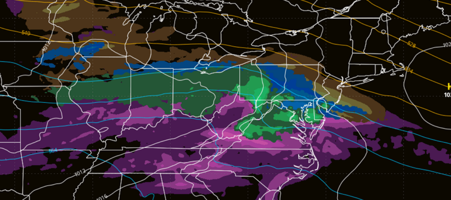
I’m continuing to see a pattern, favorable for snowstorm development, unfold beyond Feb 10 and last for a few weeks…an onslaught of active lows. Is it a perfect -NAO/-AO/+PNA/-EPO (Greenland block /Arctic air spill available/Alaska-W US ridge) pattern? No. The PNA looks negative in the foreseeable future which means a W US trough feeding the Mid-Atlantic US a SouthWest Flow Event (SWFE) Pattern ridge. This means that lows are expected to round the W US trough and track across the US, N and W of NJ. The warm moist SW flow from the low’s warm sector then rises over the colder lower-level air, reinforced by New England high pressure (cold air damming) which creates a snow to sleet to freezing rain to rain situation for all areas to the SE and especially S of the low. However, it creates more of a snow only situation for all areas E and especially NE of the low. So, your location is paramount with respect to the thermal gradient boundary, that is expected to set up from the SW US and extend E/NE to the Mid-Atlantic US.
I’m currently watching three systems that will likely take this SW US to Mid-Atlantic US track and slam into colder air at the surface to create wintry impact events. The first two systems (Feb 6 and Feb 8-9) should place NJ on the SE side of the low…meaning likely a snow to ice to rain scenario for most of NJ. The third system looks colder and more wintry with NJ more on the N side of the low. That will be mainly because of being beyond the Feb 10 pattern change. So the next three systems identified above should become a little colder with each one. There are more systems beyond these three, which is why you are likely seeing total run snow maps posted on social media suggesting apocalyptic snow amounts. Could they play out? Sure, but you have to realize that those are total accumulative snow maps for 15 days which can include multiple snow systems. It’s not going to all fall at once.
I’m usually not a fan of long-range snow accumulation maps. They usually just make hype casters look bad, send people to the grocery stores unusually early, and generate public panic. But in this case, I think it lends credence to evolving pattern since all three big global operational models (GFS, Euro and Canadian) and their ensemble members are suggesting the same thing, not just with surface snow output but more so with the upper level look of the -NAO/-AO/-PNA/-EPO pattern progressively turning colder. All data basically suggests a wintry Feb 10 to at least Feb 20. A general theme of below average temperatures with above average precipitation. Very different than the current pattern expected to last until Feb 10 which is a series of temp spikes and pits. So let’s move onto this week’s forecast.
I hit 52F in my backyard today and it felt marvelous to step outside in the sun for a bit, especially just getting over being sick. Most of NJ hit the 40s/50s today. I expect a similar day tomorrow Tuesday) before temperatures crash tomorrow night. Tuesday night will dip into the upper teens/20s and Wednesday will likely max out near-freezing in the afternoon. Wednesday night temps should drop back into the 20s statewide which sets the colder surface stage for the precipitation late Wednesday night through Thursday (storm #1). I expect an initial snow burst for at least NNJ (N of I-195). I then expect snow to change to sleet then freezing rain then plain rain from S to N throughout the system. Thursday afternoon should eventually reach the 36-40 range (N to S), melting a lot of whatever falls in the AM hours of Thursday while the surface is still cold. Temps could actually drift higher into the evening due to synoptic driven warmth. But this will likely be after the wintry damage is done earlier in the morning. I foresee lots of travel disruption Thursday morning, especially N of I-195. SNJ should warm quick enough to minimize wintry precip and maximize regular rain. We will put out expected maps for snow, ice, and rain starting tomorrow but we aren’t there just yet.
After Thursday’s system wraps up, we then stay in another mild period through Saturday where temps push into at least the 40s, possibly 50 statewide (Fri and Sat). Temps then crash again Saturday night ahead of storm #2 which should be very similar to storm #1 but occurring this Saturday night into Sunday). Likely snow for NNJ/Rain for SNJ…warmer transition to ice then rain S to N…. A slippery Sunday morning N of I-195 – Sunday afternoon then 40-50 statewide.
Storm #3 is the furthest immediate signal out there for the Feb 12-14 period. By that time, the gradient thermal boundary should be adjusted S of NJ with the colder pattern. If that signal comes to fruition, it would be more of a statewide snow event rather than a NNJ/CNJ wintry-only event that turns to rain. And then after that are even more signals through at least Feb 20.
In English: Throw your automated app temps out for this next week of roller coaster temps. If I hear one person say “It won’t snow because my app says it’s going to be 40-50” I’m going to dish out virtual noogies and direct you to the text you didn’t’ read. Yes, daytime temps will spike this week but on a few of those nights, they will drop below freezing ahead of precipitation pushing into NJ…Wednesday night and Saturday night. Both of these systems will likely throw transitional wintry precipitation down on at least the N half of NJ possibly the N 2/3 of NJ (late-Wednesday night into Thursday morning (Feb 5-6) and late Saturday night into Sunday morning (Feb 8-9)). SNJ/SENJ stands the best chance for little wintry/mostly rain. NNJ/NWNJ stands the best chance for the most amount of wintry/least amount of rain. CNJ will be a battleground featuring less wintry than NNJ but less rain than SNJ. Then wash rinse repeat for Saturday night into Sunday and then we transition into more of a snow pattern for a 3rd signal Feb 12-14. This is the best I can do for now. Tomorrow, we’ll likely start wintry impact maps for Wednesday night into Thursday morning. Have a great rest of your Monday and please be safe! JC
Premium Services
KABOOM Club offers ad-free content, inside info forecast discussion, your questions answered, and early storm impact maps and video releases (ahead of the public). At two bucks per month, it’s an extremely feasible way to show additional support for Weather NJ. Think of it as a tip jar with perks. Available onFacebook or Patreon.
My Pocket Meteorologist (MPM), in partnership with EPAWA Weather Consulting, offers professional/commercial interests, whose businesses depend on outdoor weather conditions (snow plowing, landscaping, construction, etc.), with hyper-local text message alerts/forecasts and access to the MPM premium forum—the most comprehensive and technical forecast discussion available for PA and NJ.
Jonathan Carr (JC) is the founder and sole operator of Weather NJ, New Jersey’s largest independent weather reporting agency. Since 2010, Jonathan has provided weather safety discussion and forecasting services for New Jersey and surrounding areas through the web and social media. Originally branded as Severe NJ Weather (before 2014), Weather NJ is proud to bring you accurate and responsible forecast discussion ahead of high-stakes weather scenarios that impact this great garden state of ours. All Weather. All New Jersey.™ Be safe! JC


LOCAL FORECAST | INTERACTIVE RADAR | LATEST NJ WEATHER ALERTS | WEDDING FORECAST| PRIVACY POLICY
© Copyright 2025 Weather NJ LLC. All Rights Reserved.
Some information that can be found on our website is provided by a private weather station and is not an officially recognized station for weather reporting. Though we always strive to achieve accurate reporting for our own use, it is important that you do NOT depend on the data provided here for any purpose.
