Sunday Snowstorm Developing

Discussion: Today and tomorrow are milder as expected. Afternoon temps are ranging from 38-44 today (Friday) and possibly a few degrees warmer tomorrow (Saturday). Sunday should then reach the mid-to-upper 30s for afternoon high temps before falling below freezing for most of NJ by late-afternoon as snow arrives and spreads into New Jersey.
A weak and milder system could bring rain to NJ on Saturday. It’s not much rain at all as the system is starved for moisture. But this system is important because it will set the thermal boundary behind it for Sunday’s snowstorm to track along and basically ride. The storm low will be born early Sunday morning over W VA/NC and then track across S Delmarva either near or offshore of NJ Sunday afternoon-evening…and that’s our storm low.
On the NW side of the storm low, a precipitation shield should form Sunday morning over KY/TN which should track straight towards NJ, bringing snow to much of NJ, and possibly some mixed precipitation to SENJ areas, during Sunday afternoon-evening hours. Timing could spill a little past midnight (Monday morning) but I’m thinking most areas should wrap up prior to midnight (Sunday night).
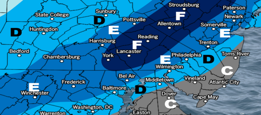
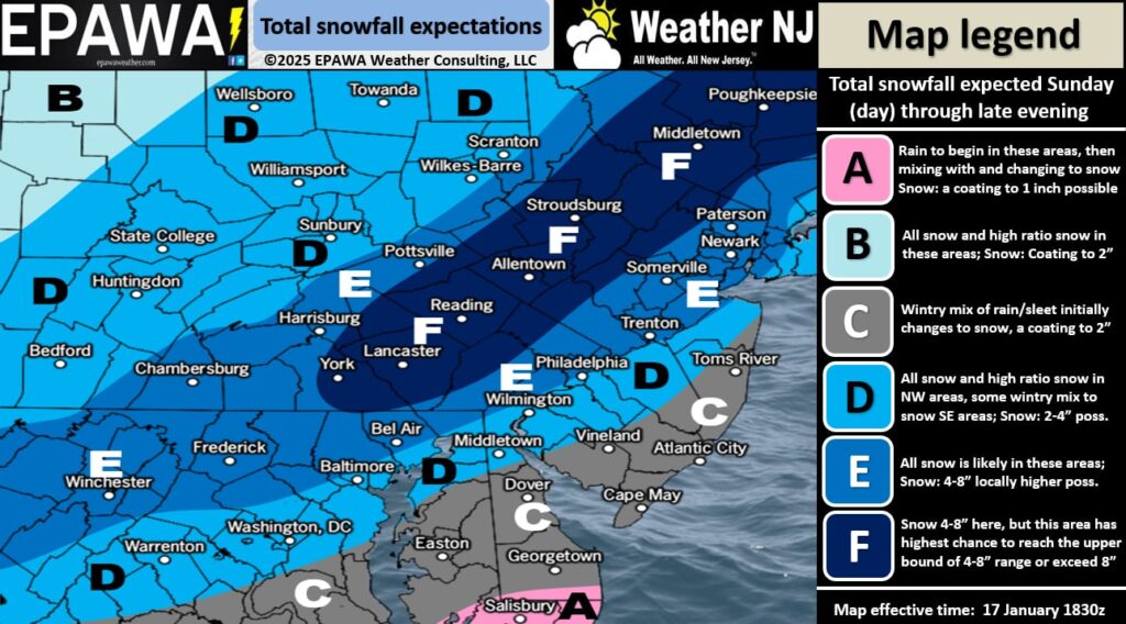
This is our initial snow map and forecast for this Sunday. This will allow us the ability to make adjustments tomorrow (Saturday) if needed based on guidance trends and live observations. But for right now (Friday) this is the result of our comprehensive analysis which began many days ago for this system:

Zones E and F are the jackpot zones that should at least see 4 inches of accumulation but could see up to 8 or more depending on where exactly the axis of heaviest snow bands sets up within the overall zone E. In these areas, temperatures will be very cold during snowfall (18-25) which will allow higher snow ratios and a more powdery accumulation.
Zone D is the most uncertain zone. It could behave like E or C depending on where the thermal boundary sets the low up to ride and ultimately where the snow/rain line forms.
Zone C is the heartbreak zone for the snow lover. Most models have trended towards a shallow warm layer being pulled off the ocean and affecting frozen precipitation with meltage. Whether it’s just a shallow layer or something thicker will determine sleet vs rain. Freezing rain will likely not be an issue with how mild it will be today (Friday) through Sunday morning.
Once this system clears out, a very cold air mass is expected to push into NJ. We’re talking about Arctic air with a Siberian source. It will likely be the coldest air of winter so far, and we’ve seen some cold air already! If there are any wet roads leftover from Sunday, expect them to freeze. This is the kind of cold that salt doesn’t work in. I expect this very cold air mass to linger around from Monday well into next week including during another snowstorm signal Wednesday Jan 22. I will begin looking at that in more detail tomorrow into Sunday. Most focus will remain on this Sunday however.
In English: After a milder Friday-Saturday and Sunday start, temps will drop and snow will push into SWNJ as early as Sunday afternoon. Snow should then spread into the rest of NJ (possible mixing issues for SNJ/SENJ) by late Sunday afternoon, peak around Sunday evening, and then taper off likely before midnight Sunday night. Any SNJ/SENJ areas that start as a mix of sleet/rain should finish with snow Sunday night, hence the smaller accumulation numbers for SNJ/SENJ. There’s a small chance that end timing spills into early Monday AM hours but most should wrap-up before midnight Sunday night/Monday morning. The above snow map represents how much snow we think will fall and accumulate. This is our first and official forecast for this Sunday system. We will update tomorrow if needed and start live observations Sunday morning. Everyone have a great rest of your Friday and please be safe! JC
Premium Services
KABOOM Club offers ad-free content, inside info forecast discussion, your questions answered, and early storm impact maps and video releases (ahead of the public). At two bucks per month, it’s an extremely feasible way to show additional support for Weather NJ. Think of it as a tip jar with perks. Available onFacebook or Patreon.
My Pocket Meteorologist (MPM), in partnership with EPAWA Weather Consulting, offers professional/commercial interests, whose businesses depend on outdoor weather conditions (snow plowing, landscaping, construction, etc.), with hyper-local text message alerts/forecasts and access to the MPM premium forum—the most comprehensive and technical forecast discussion available for PA and NJ.
Jonathan Carr (JC) is the founder and sole operator of Weather NJ, New Jersey’s largest independent weather reporting agency. Since 2010, Jonathan has provided weather safety discussion and forecasting services for New Jersey and surrounding areas through the web and social media. Originally branded as Severe NJ Weather (before 2014), Weather NJ is proud to bring you accurate and responsible forecast discussion ahead of high-stakes weather scenarios that impact this great garden state of ours. All Weather. All New Jersey.™ Be safe! JC


