

Another Major Hurricane to Cripple W Florida
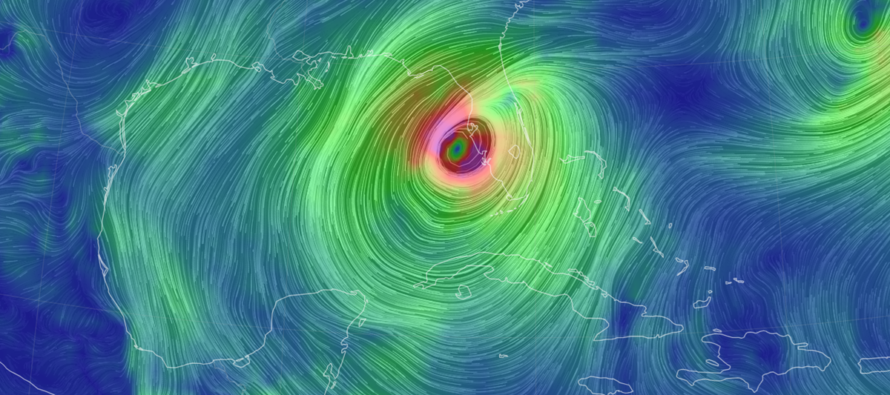
Discussion: This is another article that has little-to-no value for New Jersey weather interests. The only effect Hurricane Milton might have on New Jersey beaches are some slightly enhanced rip currents once Milton is out to sea near Bermuda later this weekend. And even that might be a stretch. This article is a deep dive into another major hurricane about to make a historic landfall in Florida with the hopes that you can pass this info to any friends and family you have down there who aren’t taking it seriously enough. Unfortunately, and I don’t use this term lightly, parts of the W FL coast are in another “GTFO or die” situation. Let’s start with the latest graphic update from NOAA National Hurricane Center (NHC):
As of the 11am update, Major Hurricane Milton has been downgraded to a strong category 4 hurricane. This is likely due to shear and dry air working into the system. Up until early this morning, Milton was allowed to pass over very warm water with negligible shear—creating a rich environment for tropical cyclone intensification, especially when it was passing/grazing the N Yucatan Peninsula. This is why it flexed so low in pressure/high in winds the last few days. But now that it is encountering the shear and dry air, there is some weakening going on as expected. Additionally, NHC has confirmed Milton is now entering another Eye Wall Replacement Cycle (ERC or EWRC). This happens when a slightly larger eye forms outside of the smaller eye and things in the eye sort of “gravitron” outwards against the newly formed larger eye wall. It is traditional for EWRC to temporarily weaken a tropical cyclone but also traditional for it to strengthen after the EWRC is complete. Tonight, as Milton pushes onshore, I will be curious to see if Milton weakens more, holds strength, or intensifies back to cat 5. We’ll have the EWRC completion vs the shear and drier air…so any scenario is possible. But even if it weakens slightly more, Milton should still make landfall as at least a category 3 hurricane which is absolutely capable of changing entire coastlines and marine communities forever. Once Milton crosses FL, it will weaken significantly and speed off to the E/NE towards Bermuda.
My best guess estimate for landfall is somewhere along the W FL coast in the general strip running from Anna Maria to Siesta Key, placing Sarasota and Bradenton areas in the immediate aftermath. I expect this landfall to happen between later tonight (Wednesday) and early tomorrow (Thursday) AM hours. Let’s call it between 8pm tonight and 4am tomorrow morning. Let’s further break down the primary impacts:
Wind: I do not see this making landfall as less than a category 3 major hurricane. 4 and 5 are on the table but for the purposes of safety and conservative estimation, assume a cat 3 landfall minimum. This is enough wind to cause catastrophic damage to most structures. Areas to the S of the eye will take the brunt of the cyclonic wind (remember to add the speed of storm to the winds on S of eye wall). My best guess from here is that the Sarasota/Siesta Key area will encounter this. Outside of the eye wall winds are winds that Florida has dealt with many times before (the 70-90mph stuff or less). I’m thinking this is N of Tampa and S of Venice. But inside of that should be the truly destructive and catastrophic winds. Here is to hoping the winds are closer to cat 3 than 5. Also remember that if you take eye wall winds head on then you will also take the back-side of the eye wall winds coming from the opposite direction. These winds should move across FL from W/SW to E/NE between tonight and later Thursday morning. The wildcard for wind are tornadoes that can form anywhere ahead and outside the hurricane. I am seeing some tornado reports outside the Fort Lauderdale area already. Tornadoes like to form on the E/NE side of the hurricane due to the cyclonic winds shearing against the front of the upper-level circulation.
Storm Surge: Surge is wind driven. Milton’s higher wind radius is expected to expand after the EWRC is completed. This means there will be a larger area of wind on the eye’s S side pushing more Gulf of Mexico water into the W FL coast later today/tonight. This places the general Tampa Bay area and other coastal spots S of that in the worst risk area for wind driven storm surge. The latest estimates I’ve seen are for water levels 10-15 feet above normal…absolutely crippling for those in the same area that just dealt with a 5-10 foot storm surge from Helene. Surge will be less as you head N and S along the W FL coast but much of the W FL coast is on the hook for some level of surge.
Rain: Milton will not have the same impact as Helene did rain-wise. Helene was a completely different situation as it stalled over the interior SE US and dropped 20-30 inches of rainfall on the lower Appalachian Mountains after 5-10 inches of pre-storm rainfall. Milton will instead pass thorough FL from W to E without a stall. This could still drop 5-10 inches of rainfall across C FL, maybe a bit more in some spots, which is a lot, but not 30-40 inches total like Helene. Also, Florida has much better drainage than the river and dam situations of S Appalachia. So, there will be a lot of rain from Milton but the primary concerning impacts of Milton are wind (eye wall and tornadic) and surge.
In English: If you live along/near the W coast of FL between the general strip of Spring Hill and Venice, especially the Bradenton/Sarasota areas, you should be evacuating now if you haven’t already. You do not have much time left. Conditions will rapidly deteriorate hourly starting late this afternoon and should be catastrophic by later tonight/overnight into tomorrow morning. If you are away from the coast, make sure you are in a dry place capable of withstanding high winds and expect power outages. There’s not much more to say about this system from a NJ weather outlet’s point of view other than please pass this along to anyone you know down there. Local Florida social media will be your best source for coverage, especially from hurricane/storm chasers. There remains no threat to NJ from Milton. The regularly scheduled weekend outlook for NJ will be released tomorrow (Thursday). Be safe! JC
Premium Services
KABOOM Club offers inside info forecast discussion, your questions answered, and early storm impact maps (ahead of the public). At a buck per month, it’s an extremely feasible way to show support.
My Pocket Meteorologist (MPM), in partnership with EPAWA Weather Consulting, offers professional/commercial interests, whose businesses depend on outdoor weather conditions (snow plowing, landscaping, construction, etc.), with hyper-local text message alerts/forecasts and access to the MPM premium forum—the most comprehensive and technical forecast discussion available for PA and NJ.
Jonathan Carr (JC) is the founder and sole operator of Weather NJ, New Jersey’s largest independent weather reporting agency. Since 2010, Jonathan has provided weather safety discussion and forecasting services for New Jersey and surrounding areas through the web and social media. Originally branded as Severe NJ Weather (before 2014), Weather NJ is proud to bring you accurate and responsible forecast discussion ahead of high-stakes weather scenarios that impact this great garden state of ours. All Weather. All New Jersey.™ Be safe! JC


LOCAL FORECAST | INTERACTIVE RADAR | LATEST NJ WEATHER ALERTS | WEDDING FORECAST| PRIVACY POLICY
© Copyright 2026 Weather NJ LLC. All Rights Reserved.
Some information that can be found on our website is provided by a private weather station and is not an officially recognized station for weather reporting. Though we always strive to achieve accurate reporting for our own use, it is important that you do NOT depend on the data provided here for any purpose.
