

Tropical Remnants Approaching
Discussion: Let’s first realize that we’re only 36 hours from the most immaculate summer weather possible. When a tropical system moves through our region, they tend to scoop up and carry away regional humidity, leaving extra-dry, sunny, and comfortable feel in its wake. That’s what’s on deck for Saturday and Sunday and likely into early next week. We’re talking afternoon highs in the low-80s with dew points in the 50s or less. We’re also talking clear and cooler nights with overnight low temperatures near-60 or less. Weather expectations this coming weekend can be best summed up with 8) Now let’s talk about Debby’s remnants.
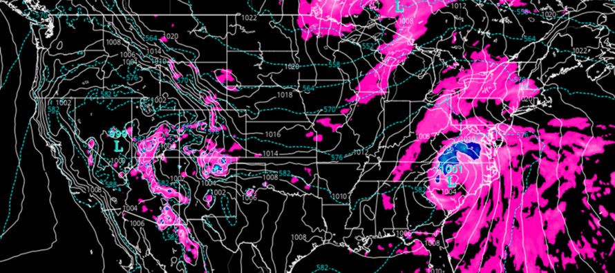
Rain first. Debby continues to favor a track well to the W of NJ, she’s currently tracking northward through the Carolinas and Virgina and should be over PA on Friday before ultimately tracking NE over New England by early Sunday morning. This westward track means a few things for NJ. First, it means less rainfall than everyone expects. Some of the media ran with 10+ inch rainfall expectations earlier this week. In reality, the westward track means that some areas in NJ will struggle to see an inch. The NWNJ elevations have the best chance to exceed 1 inch, maybe flirt with 2. SENJ might only see a half inch to an inch of rain at most. Despite these lesser rainfall expectations, it will be much needed and will still be beneficial to water levels and aquafers. Some outer bands of rain tried to push into NJ today but much of it was knocked down by the dry sinking air associated with the temporary high near the Mid-Atlantic US coast. This high/ridge will move out and finally allow Debby’s remnants to push through between tonight and tomorrow night. With that said, expect current isolated/scattered showers to expand and become more of a widespread rainfall between tonight and tomorrow. As far as rain ending time, this might all clear through as early as daybreak Saturday morning.
Now let’s talk wind. There’s going to be a solid fetch off the ocean feeding the centralized low pressure of Debby’s remnants. Luckily, the wind direction will be more southerly than easterly on Friday which is kinder to coastal flooding interests. Winds should be in the 15-25mph sustained range with gusts to 40mph. Coastal regions will feel this wind more than areas away from the ocean and up in NNJ elevations. It’s nothing destructive, more of just a widespread moderate wind event. But that’s overall as a whole…synoptically. On a much more isolated/meso basis exists a non-zero chance of a tornado threat. When tropical systems get over land, the NE quadrant allows for higher levels of vertical wind shear. Surface winds are rotating around the low in this quadrant while the mid-level flow heads N or even N/NE with the jet. The difference in wind direction over altitude creates roll in the atmosphere and all you need is a updraft to stand the roll up and have the roll tail drop to the surface. Again, a low but non-zero chance of a tornado on Friday when Debby’s remnants are to our W. So widespread moderate winds with localized isolated higher winds due to either a straight-line thunderstorm outflow or tornado.
As I said above in the wind paragraph, S/SE winds are kinder on coastal flooding interests than E, E/NE, or E/SE winds. I think minor coastal flooding will be the extent of it. And with the lesser expected rainfall, there will be less rain that has nowhere to drain. If you normally see water in the streets during traditional/typical nor’easters, then you will probably see it on Friday. You won’t have to pick two of every animal though. Routine minor coastal flooding is the most reasonable expectation given the speed of the storm and the westward track of Debby into PA.
In English: Some rain bands are pushing from S to N in NJ now. Rainfall will expand to include more of NJ by late tonight/tomorrow morning and then rain on and off through Friday night/early Saturday morning. Rainfall should end quickly early on Saturday morning allowing a rain-free Saturday (after 7am) and Sunday (all day). Overall winds from Debby should only be moderate and manageable. Still a chance for some power outages but non-destructive winds in-general. At a more isolated/localized basis, severe thunderstorm winds and/or weak tornadoes are possible all day on Friday. Coastal flooding looks to stay in the minor category at most. So the most reasonable expectation are periods of moderate-to-heavy rainfall, moderate winds, and minor coastal flooding. A less probable (wildcard) outcome are severe winds/tornadoes. Everything gets started tonight, peaks on Friday, and clears by early Saturday morning with blissfully pleasant conditions for the rest of the weekend into early next week. Everyone have a great rest of your Thursday. Live tracking begins later tonight. Be safe! JC
Premium Services
KABOOM Club offers inside info forecast discussion, your questions answered, and early storm impact maps (ahead of the public). At a buck per month, it’s an extremely feasible way to show support.
My Pocket Meteorologist (MPM), in partnership with EPAWA Weather Consulting, offers professional/commercial interests, whose businesses depend on outdoor weather conditions (snow plowing, landscaping, construction, etc.), with hyper-local text message alerts/forecasts and access to the MPM premium forum—the most comprehensive and technical forecast discussion available for PA and NJ.
Jonathan Carr (JC) is the founder and sole operator of Weather NJ, New Jersey’s largest independent weather reporting agency. Since 2010, Jonathan has provided weather safety discussion and forecasting services for New Jersey and surrounding areas through the web and social media. Originally branded as Severe NJ Weather (before 2014), Weather NJ is proud to bring you accurate and responsible forecast discussion ahead of high-stakes weather scenarios that impact this great garden state of ours. All Weather. All New Jersey.™ Be safe! JC


LOCAL FORECAST | INTERACTIVE RADAR | LATEST NJ WEATHER ALERTS | WEDDING FORECAST| PRIVACY POLICY
© Copyright 2025 Weather NJ LLC. All Rights Reserved.
Some information that can be found on our website is provided by a private weather station and is not an officially recognized station for weather reporting. Though we always strive to achieve accurate reporting for our own use, it is important that you do NOT depend on the data provided here for any purpose.
