

Storms Tonight and Debby Update
Discussion: With the expected storms today/tonight and remnant impacts from Debby later this weekend, we’re switching to article mode rather than the typical weekly outlook. I’ve been away for the past few days. If you can believe it, my daughter turned 5 years old, so we had a nice staycation over the weekend and enjoyed some of the things NJ offers locally. Everyone says don’t blink because they grow up so fast. It’s true. All of it. Thank you for your patience and understanding. Now back to the weather.
First, let’s sum up the week in general before diving into the two specific near-future events. This week looks like a transitional period for the entire summer. The relentless tropical patterns that have dominated summer so far should relax by the end of this weekend and then stay reasonable as far as I can see in August. When I say reasonable, I mean highs in the 80s with average humidity…not highs 90+ with dews 70+. We should get there by Sunday morning. Today should be the last very hot and humid day away from the ocean. All of NJ then steps down in temperature Wednesday-forward (some days capped in the 70s) but the humidity lingers through at least Saturday morning in some way, shape, or form. The headline of this week will likely be rainfall totals between today and Saturday as many drought-building areas likely see inches of rainfall. Now let’s break down the main events of this week.
A frontal boundary is currently draped in a zonal W to E flow/orientation through PA into NNJ. This boundary will be slowly sinking S between today (Tuesday) and tomorrow (Wednesday). It will be over NNJ/CNJ today (Tuesday) and SNJ tomorrow morning (Wednesday morning). This W to E frontal boundary will focus the heaviest rainfall beneath it. With that said, NNJ/CNJ should see the most rain between this afternoon and overnight while SNJ gets in on the rainfall tomorrow morning with a slow taper by tomorrow afternoon/early evening. Debby will not be merging into this frontal boundary, but Debby will throw moisture into it from the S which should enhance and concentrate the rainfall along the frontal boundary. You can expect embedded thunderstorms at anytime within/under this frontal boundary. So NJ is looking at a rainy/stormy period…NNJ/CNJ today and tonight (higher rain totals)…SNJ tomorrow morning (lower rain totals). A ridge then builds into the Mid-Atlantic/NorthEast US Wednesday night through Friday morning which separates the frontal boundary interaction with Debby temporarily before another trough moves in to pick Debby’s remnants up and take them over/near NJ Friday-Saturday. With that said, a break is expected between the rain ending Wednesday PM and Debby’s remnants approaching Friday. Though I’m not sure how much clearing there will be during this break. It will still likely be cloudy and humid with isolated/scattered showers around.
On Friday, Debby’s remnants should finally be allowed to leave the SW US and slide up the east coast/E US. The temporary ridge (that will hold Debby in the SW US for next few days) will lift out and Debby’s central low location should pass through or near NJ from SW to NE. At this point, the main impact on land from Debby is heavy rainfall capable of producing flash flooding. Winds could still howl, don’t get me wrong, but they will likely not be in the damaging category (70+ mph) like winds you’d see on the inner eye wall of a tropical cyclone. When Debby passes over NJ, it will be weakened to a extra-tropical cyclone, what we know as a routine mid-latitude cylone (wider wind field but lower winds). So heavy rainfall and moderate winds are a good bet for Friday into at least Saturday morning. And honestly, this seems like a situation where winds will not be much of an issue away from the coastal regions. Coastal regions (ECNJ/SENJ) have some additional hazards to expect. There will be onshore flow from Thursday through Saturday. The onshore flow is mainly out of the E Thursday into Friday then turning out of the S/SE Friday into Saturday. During this period, coastal regions should expect at least some coastal flooding in the streets with a better chance of beach erosion and enhanced surf along beaches.
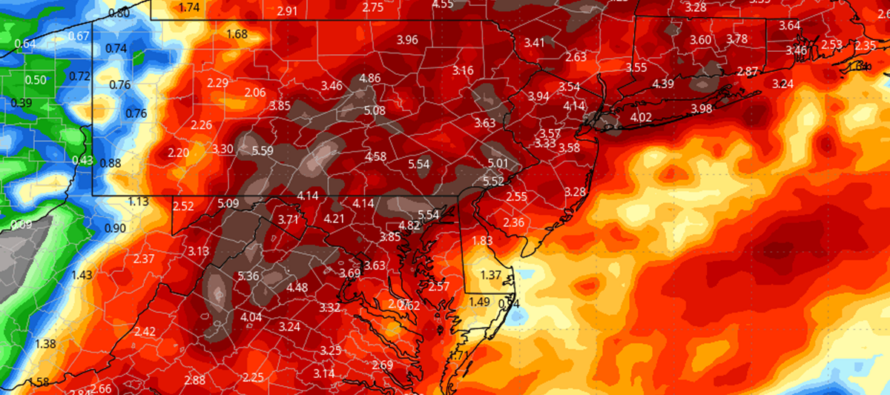
Once Debby’s remnants clear out (could be as early as Saturday morning), we should see the humidity depart with it, leaving a nice rest of the weekend. Right now, the second half of Saturday through all of Sunday looks immaculate. With any luck, that will include a little more of the first part of Saturday. This is yet TBD. This nice weather should then spill into next week. Just know that come Saturday when skies improve, NJ will likely have experienced inches of rainfall. The above image shows the Euro’s total rainfall output between now and Saturday.
In English: NNJ/CNJ should expect heavy rain and thunderstorms from this afternoon (Tuesday) through tonight. SNJ should then expect such between tonight and tomorrow afternoon (Wednesday). This is not directly from Debby though it will be enhanced by Debby in a secondary manner. We then see a break with lower temps in the 70s/lower-80s, but still humid and cloudy with isolated rain activity, Wednesday night through Friday morning. Debby’s remnants should then bring more heavy rain to NJ between Friday and Saturday morning. Winds should not be horrible but felt most along the coast. Coastal flooding is likely between Thursday night and Saturday mainly for SNJ/SENJ, maybe ECNJ. I will be updating daily as we approach. Have a great week and please be safe! JC
Premium Services
KABOOM Club offers inside info forecast discussion, your questions answered, and early storm impact maps (ahead of the public). At a buck per month, it’s an extremely feasible way to show support.
My Pocket Meteorologist (MPM), in partnership with EPAWA Weather Consulting, offers professional/commercial interests, whose businesses depend on outdoor weather conditions (snow plowing, landscaping, construction, etc.), with hyper-local text message alerts/forecasts and access to the MPM premium forum—the most comprehensive and technical forecast discussion available for PA and NJ.
Jonathan Carr (JC) is the founder and sole operator of Weather NJ, New Jersey’s largest independent weather reporting agency. Since 2010, Jonathan has provided weather safety discussion and forecasting services for New Jersey and surrounding areas through the web and social media. Originally branded as Severe NJ Weather (before 2014), Weather NJ is proud to bring you accurate and responsible forecast discussion ahead of high-stakes weather scenarios that impact this great garden state of ours. All Weather. All New Jersey.™ Be safe! JC


LOCAL FORECAST | INTERACTIVE RADAR | LATEST NJ WEATHER ALERTS | WEDDING FORECAST| PRIVACY POLICY
© Copyright 2025 Weather NJ LLC. All Rights Reserved.
Some information that can be found on our website is provided by a private weather station and is not an officially recognized station for weather reporting. Though we always strive to achieve accurate reporting for our own use, it is important that you do NOT depend on the data provided here for any purpose.
