Sept 14: Monitoring Jose

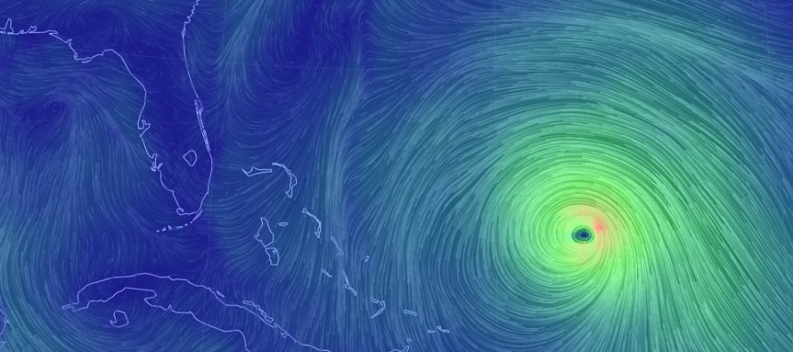
Discussion: Jose is currently a strong tropical storm positioned between Puerto Rico and Bermuda. The system is emerging from the loop it just took and is now moving W/NW towards the SE US. Jose is expected to re-gain hurricane status but likely not major hurricane status. In general, trade winds blow across from Africa towards the Caribbean, just N of the equator. Further north, including most of US and S Canada, the mid-latitude westerlies blow from the Pacific coast towards the Atlantic Coast and ultimately towards Europe. Most tropical cyclones are subject to taking the general clockwise transition from trade winds towards the westerlies. We know this as a re-curve and it dominates the entire pattern in all three tropical-cyclone areas of the world.
The most realistic and reasonable expectation is for Jose to re-curve from a heading of W/NW to NW to N and then to ultimately to the NE. The question is how close does Jose get to New Jersey next ~Wednesday through Thursday during this re-curve? Close enough to rough up the surf and generate above-average tidal conditions? Yes, this is likely for most of the Mid-Atlantic US coastline. Close enough to possibly bring some outer-band rain and moderate winds to the region? Possibly…OBX and Cape Cod would have the best chance given their geographic extension into the Atlantic Ocean. Close enough for a direct NJ landfall? Possible but not probable. The re-curve which would keep Jose off of our coastline is dependent on an upper-level trough splitting the Canadian ridge while moving W to E across Canada. This feature is heavily modeled by both the Euro and GFS at this point and only some interaction is required for the trough to curve Jose out to sea (not a full capture is required).
Direct landfall to New Jersey would be the wildcard scenario and would mean Jose misses the trough connection completely. If that were the case then Jose would slowly drift to the west towards New Jersey/east coast. Once over the colder waters above the continental shelf, Jose would weaken and lose its tropical core. It would not be moving fast like Sandy did nor would it have Sandy’s intensity. Also the system would weaken from a central pressure standpoint as well as encounter unfavorable shear from the mid-to-upper levels. In this scenario, New Jersey would likely be looking at a stubborn minor-to-moderate nor’easter like system. There would be noticeable rain, wind and coastal flooding but nothing we don’t see a few times a year. In this scenario, the destructive core tropical winds would likely be removed from the equation.
In English: The most likely outcome for Jose is a curving miss to New Jersey. This miss could range from less than 200 miles offshore up to 1000 miles offshore. A track closer to NJ could mean a day or two of enhanced NE winds, minor-to-moderate coastal flooding and possibly some outer-fringe rainfall in the Wednesday-Thursday period of next week. A track further offshore would remove most of the rain potential but still carry the chance for less intense NE winds and minor coastal flooding. A small wildcard chance says Jose could make the turn westward towards NJ as a weaker system. This would likely produce a stronger nor’easter-like environment for New Jersey but nothing catastrophic. I’m currently leaning towards the re-curve miss just offshore but keeping the turn W on the table as a small wildcard possibility. Either way marine conditions (wave heights and rip currents) should deteriorate between now and next weekend. Let’s see how model guidance and observations continue to evolve. Be safe! JC
Jonathan Carr (JC) is the founder and sole operator of Weather NJ, New Jersey’s largest independent weather reporting agency. Since 2010, Jonathan has provided weather safety discussion and forecasting services for New Jersey and surrounding areas through the web and social media. Originally branded as Severe NJ Weather (before 2014), Weather NJ is proud to bring you accurate and responsible forecast discussion ahead of high-stakes weather scenarios that impact this great garden state of ours. All Weather. All New Jersey.™ Be safe! JC


