Oct 9: Rain to clear from W to E

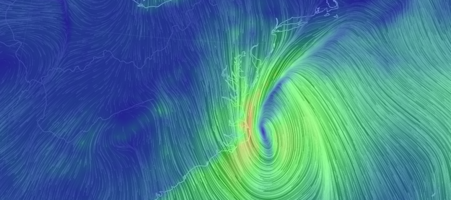
Matthew is now extra-tropical and moving away from the US East Coast well to our S. The cold front is pushing through from the W which has enhanced rainfall for the Mid-Atlantic. North Carolina and Virginia have seen some pretty crazy rainfall and we’re not completely finished just yet. Matthew however is mostly finished. He will now absorb into the cold front as his remnants move out to sea—removing the loop idea from the table.
Rain has ended for DC and Baltimore and will end for the Delaware Memorial Bridge area in the next hour or so. I expect rain to end for far east points of NJ (especially Ocean and Monmouth County) by 2PM. Between now and then, enhanced rainfall will remain possible but it is indeed ending.
You can make out the cold front on the image above by tracing the higher wind line from the tip of Long Island into the center of Matthew. Because we are now on the W side of the front, we’re subject to northerly winds coming out of Canada (which I know you’re feeling). Winds will be strongest out of the N just to the W of the cold front. These N winds should subside overnight as the flow relaxes and as the current dynamics move further E into the Atlantic Ocean. The N winds should help shred apart the W side of Mathew’s precipitation shield over the next few hours and will also be the reason for the cool down this coming week.
In English: Rain, heavy at times, will end from W to E over the next few hours. It will end last for coastal Ocean and Monmouth Counties which could be as late as 2PM but possibly earlier. I was originally thinking by late morning for the coast but that now looks like early afternoon. Northerly winds will be strongest today but will subside overnight. This is all ushering in dry and sunny conditions yet a pretty significant cool-down that should last well into this week. Got those jackets ready? I’ll have the detailed weekend outlook posted later tonight. Be safe! JC
Jonathan Carr (JC) is the founder and sole operator of Weather NJ, New Jersey’s largest independent weather reporting agency. Since 2010, Jonathan has provided weather safety discussion and forecasting services for New Jersey and surrounding areas through the web and social media. Originally branded as Severe NJ Weather (before 2014), Weather NJ is proud to bring you accurate and responsible forecast discussion ahead of high-stakes weather scenarios that impact this great garden state of ours. All Weather. All New Jersey.™ Be safe! JC


