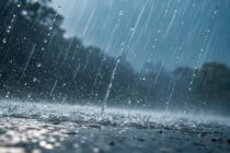
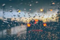
A Mixed Bag
Discussion: Most of NNJ today has reached the ~75F mark. Much of CNJ/SNJ (away from the ocean) has reached the 80F mark. Immediate ECNJ/SENJ coastal areas are hanging in the 55-65F range due to marine influence (the ocean is still


Discussion: Most of NNJ today has reached the ~75F mark. Much of CNJ/SNJ (away from the ocean) has reached the 80F mark. Immediate ECNJ/SENJ coastal areas are hanging in the 55-65F range due to marine influence (the ocean is still
Discussion: Temperatures should moderate back into the 65-75 range tomorrow (Monday) as a warm sector influences NJ with warmer temperatures and higher levels of humidity. A stormfront is then expected to pass through New Jersey from NW to SE between

Discussion: The upper jet should stay to the N of NJ this weekend before crossing S over NJ briefly Tues-Wed and ultimately returning N of NJ by Thursday of next week. This will set the stages for an abnormally warm
Discussion: A shallow positive trough will meander over NJ for much of this week, producing colder temperatures with a slightly unsettled feel. The trough should then give way to a building ridge for the weekend, yielding milder conditions. In the

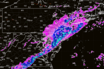
Discussion: We have a low tracking from the Great Lakes into SE Canada tonight (Thursday night). A cold front is attached to this low which should push a storm/cold front through NJ. Lightning is yet TBD but we’re at least
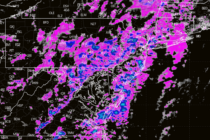
Discussion: A potent upper low has crawled across the US from W to E over the last few days…very dynamic with lots of vorticity and clashing air masses of varying temperature/moisture. At the lower levels, this has created quite the

Discussion: We’ll be in a split jet zonal pattern for this weekend into next, the N stream to the N of NJ and the S stream to the S of NJ…which is why there won’t be a phased snowstorm this

LOCAL FORECAST | INTERACTIVE RADAR | LATEST NJ WEATHER ALERTS | WEDDING FORECAST| PRIVACY POLICY
© Copyright 2025 Weather NJ LLC. All Rights Reserved.
Some information that can be found on our website is provided by a private weather station and is not an officially recognized station for weather reporting. Though we always strive to achieve accurate reporting for our own use, it is important that you do NOT depend on the data provided here for any purpose.


